- Coastal Elevations
- Wetland Accretion
- Vulnerable Species
- Societal Impacts
- Adaptation
- Elevation Maps
- Planning Maps
 Chapter 2: Coastal Elevations
Ocean Coasts
Related Links
U.S. Global Change Research Program
Other EPA-sponsored Climate Change Science Program Synthesis and Assessment Reports
By Gutierrez, B.T., S.J. Williams, and E.R. Thieler
Ocean Coasts (14 pp, 8.6MB)
was originally published as
Chapter 3 of the US Climate Change Science Program's Synthesis and Assessment Product 4.1. A reasonable way of citing this paper would be:
Gutierrez, B.T., S.J. Williams, and E.R. Thieler, 2009: Ocean coasts. In: J.G. Titus (coordinating lead author),
K.E. Anderson, D.R. Cahoon, D.B. Gesch, S.K. Gill, B.T. Gutierrez, E.R. Thieler, and S.J. Williams
(lead authors). Coastal Sensitivity to Sea-Level Rise: A Focus on the Mid-Atlantic Region.
U.S. Environmental Protection Agency, Washington DC, pp. 43-56.
The chapter's Key Findings and the sections on Coastal Landforms, General Responses and Predictions are available below online.
For additional reports focused on the implications of rising sea level, go to More Sea Level Rise Reports.
Key Findings
Coastal changes are driven by complex and interrelated processes.
- Along the ocean shores of the Mid-Atlantic, which are comprised of headlands, barrier islands, and spits, it is virtually certain that erosion will dominate changes in shoreline position in response to sealevel rise and storms over the next century.
- It is very likely that landforms along the mid-Atlantic coast of the United States will undergo large changes if the higher sea-level rise scenarios occur. The response will vary depending on the type of coastal landforms and the local geologic and oceanographic conditions, and could be more variable than the changes observed over the last century.
- For higher sea-level rise scenarios, it is very likely that some barrier island coasts will cross a threshold and undergo significant changes. These changes include more rapid landward migration or segmentation of some barrier islands.
3.5 Coastal Landforms of the Mid-Atlantic
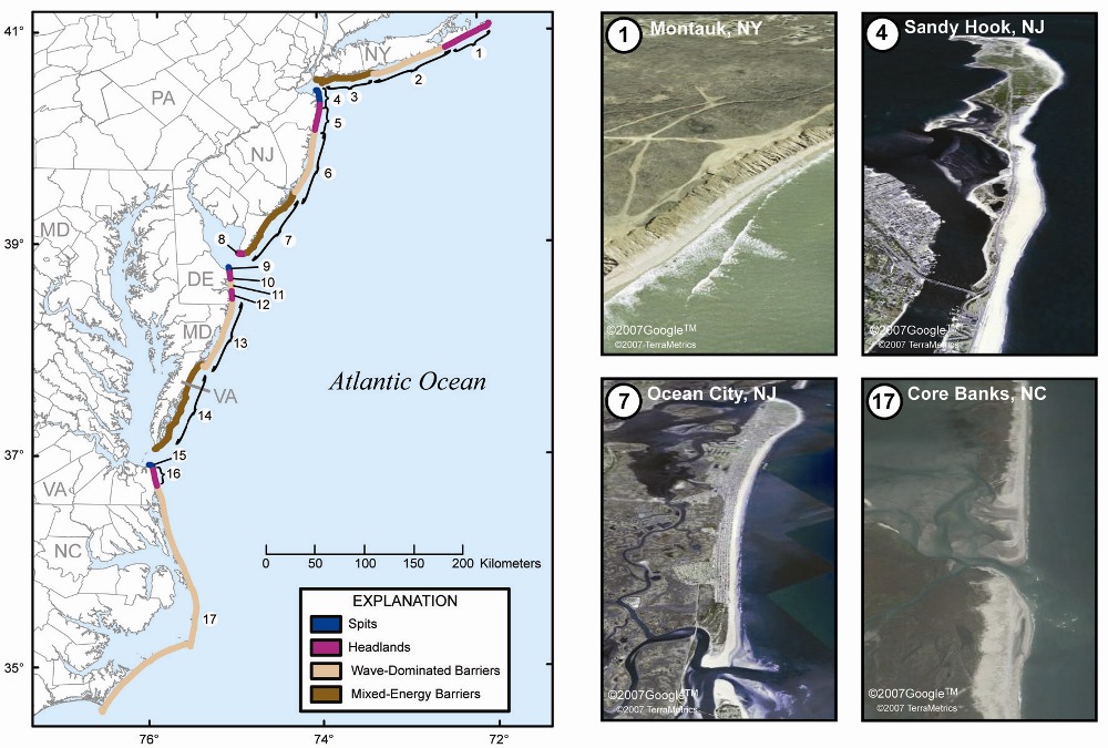
For this assessment, the coastal landforms along the shores of the mid-Atlantic region are classified using the criteria developed by Fisher (1967, 1982), Hayes (1979), and Davis and Hayes (1984). Four distinct geomorphic settings, including spits, headlands, and wave-dominated and mixed-energy barrier islands, occur in the mid-Atlantic region, as shown and described in Figure 3.1.
Figure 3.1
3.5.1 Spits
The accumulation of sand from longshore transport has formed large spits that extend from adjacent headlands into the mouths of large coastal embayments (Figure 3.1, coastal compartments 4, 9, and 15). Outstanding examples of these occur at the entrances of Raritan Bay (Sandy Hook, New Jersey) and Delaware Bay (Cape Henlopen, Delaware). The evolution and existence of these spits results from the interaction between alongshore transport driven by incoming waves and the tidal flow through the large embayments. Morphologically, these areas can evolve rapidly. For example, since 1842 Cape Henlopen (Figure 3.1, coastal compartment 9) has extended almost 1.5 kilometers (0.9 miles) to the north into the mouth of Delaware Bay as the northern Delaware shoreline has retreated and sediment has been transported north by longshore currents.
3.5.2 Headlands
Along the shores of the mid-Atlantic region, coastal headlands typically occur where elevated regions of the landscape intersect the coast. These regions are often formed where drainage divides that separate creeks and rivers from one another occur in the landscape, or where glacial deposits create high grounds. The erosion of headlands provides a source of sediment that is incorporated into the longshore transport system that supplies and maintains adjacent beaches and barriers. Coastal headlands are present on Long Island, New York (see Figure 3.1), from Southampton to Montauk (coastal compartment 1), in northern New Jersey from Monmouth to Point Pleasant (coastal compartment 5), in southern New Jersey at Cape May (coastal compartment 8), on Delaware north and south of Indian River and Rehoboth Bays (coastal compartments 10 and 12), and on the Virginia Coast, from Cape Henry to Sandbridge (coastal compartment 16).
3.5.3 Wave-Dominated Barrier Islands
Wave-dominated barrier islands occur as relatively long and thin stretches of sand fronting shallow estuaries, lagoons, or embayments that are bisected by widely-spaced tidal inlets (Figure 3.1, coastal compartments 2, 6, 11, 13, and 17). These barriers are present in regions where wave energy is large relative to tidal energy, such as in the mid-Atlantic region. Limited tidal ranges result in flow-through tidal inlets that are marginally sufficient to flush the sediments that accumulate from longshore sediment transport. In some cases, this causes the inlet to migrate over time in response to a changing balance between tidal flow through the inlet and wave-driven longshore transport. Inlets on wave-dominated coasts often exhibit large floodtidal deltas and small ebb-tidal deltas as tidal currents are often stronger during the flooding stage of the tide. In addition, inlets on wave-dominated barriers are often temporary features. They open intermittently in response to storm-generated overwash and migrate laterally in the overall direction of longshore transport. In many cases, these inlets are prone to filling with sands from alongshore sediment transport.
Overwash produced by storms is common on wave-dominated barriers. Overwash erodes low-lying dunes into the island interior. Sediment deposition from overwash adds to the islands elevation. Overwash deposits (washover fans) that extend into the back-barrier waterways form substrates for back-barrier marshes and submerged aquatic vegetation. The process of overwash is an important mechanism by which some types of barriers migrate landward and upward over time. This process of landward migration has been referred to as roll-over. Over decades to centuries, the intermittent processes of overwash and inlet formation enable the barrier to migrate over and erode into back-barrier environments such as marshes as relative sea-level rise occurs over time. As this occurs, back-barrier environments are eroded and buried by barrier beach and dune sands.
3.5.4 Mixed-Energy Barrier Islands
The other types of barrier islands present along the U.S.
Atlantic coast are mixed-energy barrier islands, which are
shorter and wider than their wave-dominated counterparts
(Figure 3.1, coastal compartments 3, 7, and 14). The term
mixed-energy refers to the fact that both waves and tidal
currents are important factors influencing the morphology
of these systems. Due to the larger tidal range and consequently
stronger tidal currents, mixed energy barriers are
shorter in length and well-developed tidal inlets are more
abundant than for wave-dominated barriers. Some authors
have referred to the mixed-energy barriers as tide-dominated
barriers along the New Jersey and Virginia coasts.
The large sediment transport capacity of the tidal currents
within the inlets of these systems maintains large ebb-tidal
deltas seaward of the inlet mouth. The shoals that comprise
ebb-tidal deltas cause incoming waves to refract around the
large sand body that forms the delta such that local reversals
of alongshore currents and sediment transport occur downdrift
of the inlet. As a result, portions of the barrier downdrift
of inlets accumulate sediment which form recurved
sand ridges and give the barrier islands a drumstick-like
shape.
3.6 Potential Responses to Future Sea Level Rise
Based on current understanding of the four landforms discussed in the previous section, three potential responses could occur along the mid-Atlantic coast in response to sealevel rise over the next century.
3.6.1 Bluff and Upland Erosion
Shorelines along headland regions of the coast will retreat landward with rising sea level. As sea level rises over time, uplands will be eroded and the sediments incorporated into the beach and dune systems along these shores. Along coastal headlands, bluff and upland erosion will persist under all four of the sea-level rise scenarios considered in this Product. A possible management reaction to bluff erosion is shore armoring (see Chapter 6). This may reduce bluff erosion in the short term but could increase long-term erosion of the adjacent coast by reducing sediment supplies to the littoral system.
3.6.2 Overwash, Inlet Processes, and Barrier Island Morphologic Changes
For barrier islands, three main processes are agents of change as sea level rises. First, with higher sea level, storm overwash may occur more frequently. This is especially critical if the sand available to the barrier, such as from longshore transport, is insufficient to allow the barrier to maintain its width and/or build vertically over time in response to rising water levels. If sediment supplies or the timing of the barrier recovery are insufficient, storm surges coupled with breaking waves will affect increasingly higher elevations of the barrier systems as mean sea level increases, possibly causing more extensive erosion and overwash. In addition, it is possible that future hurricanes may become more intense, possibly increasing the potential for episodic overwash, inlet formation, and shoreline retreat. The topic of recent and future storm trends has been debated in the scientific community, with some researchers suggesting that other climate change impacts such as strengthening wind shear may lead to a decrease in future hurricane frequency (see Chapter 1). It is also expected that extratropical storms will be more frequent and intense in the future, but these effects will be more pronounced at high latitudes (60° to 90°N) and possibly decreased at midlatitudes (30° to 60°N) (e.g. IPCC (2007).
Second, tidal inlet formation and migration will contribute to important changes in future shoreline positions. Storm surges coupled with high waves can cause not only barrier island overwash but also breach the barriers and create new inlets. In some cases, breaches can be large enough to form inlets that persist for some time until the inlet channels fill with sediments accumulated from longshore transport. Numerous deposits have been found along the shores of the mid-Atlantic region, indicating former inlet positions. Several inlets along the mid-Atlantic coast were formed by the storm surges and breaches from an unnamed 1933 hurricane, including Shackleford inlet in North Carolina; Ocean City inlet in Maryland; Indian River inlet in Delaware; and Moriches inlet in New York. Recently, tidal inlets were formed in the North Carolina Outer Banks in response to Hurricane Isabel in 2003. While episodic inlet formation and migration are natural processes and can occur independently of long-term sea-level rise, a long-term increase in sea level coupled with limited sediment supply and increases in storm frequency and/or intensity could increase the likelihood for future inlet breaching.
Third, the combined effect of rising sea level and stronger storms could accelerate barrier island shoreline changes. These will involve both changes to the seaward facing and landward facing shores of some barrier islands. Assessments of shoreline change on barrier islands indicate that barriers have thinned in some areas over the last century. Evidence of barrier migration is not widespread on the mid-Atlantic coast, but is documented at northern Assateague Island in Maryland and Core Banks, North Carolina .
3.6.3 Threshold Behavior
Barrier islands are dynamic environments that are sensitive
to a range of physical and environmental factors. Some evidence
suggests that changes in some or all of these factors
can lead to conditions where a barrier system becomes less
stable and crosses a geomorphic threshold. Once a threshold
is crossed, the potential for significant and irreversible
changes to the barrier island is high. These changes can
involve landward migration or changes to the barrier island
dimensions such as reduction in size or an increased presence
of tidal inlets. Although it is difficult to precisely define
an unstable barrier, indications include:
Rapid landward m igration of the barrier;
Decreased barrier width and height, due to a loss of sand
eroded from beaches and dunes;
Increased frequency of overwash during storms;
Increased frequency of barrier breaching and inlet
formation; and
Segmentation of the barrier.
Given the unstable state of some barrier islands under current rates of sea-level rise and climate trends, it is very likely that conditions will worsen under accelerated sea-level rise rates. The unfavorable conditions for barrier maintenance could result in significant changes, for example, to barrier islands as observed in coastal Louisiana (further discussed in Box 3.2). In one case, recent observations indicate that the Chandeleur Islands are undergoing a significant land loss due to several factors which include: (1) limited sediment supply by longshore or cross-shore transport, (2) accelerated rates of sea-level rise, and (3) permanent sand removal from the barrier system by storms such as Hurricanes Camille, Georges, and Katrina. Likewise, a similar trend has been observed for Isle Dernieres, also on the Louisiana coast. In addition, recent studies from the North Carolina Outer Banks indicate that there have been at least two periods during the past several thousand years where fully openocean conditions have occurred in Albemarle and Pamlico Sounds, which are estuaries fronted by barrier islands at the present time. This indicates that portions of the North Carolina barrier island system may have segmented or become less continuous than the present time for periods of a few hundred years, and later reformed. Given future increases in sea level and/ or storm activity, the potential for a threshold crossing exists, and portions of these barrier islands could once again become segmented.
Changes in sea level coupled with changes in the hydrodynamic climate and sediment supply in the broader coastal environment contribute to the development of unstable barrier island behavior. The threshold behavior of unstable barriers could result in: barrier segmentation, barrier disintegration, or landward migration and roll-over. If the barrier were to disintegrate, portions of the ocean shoreline could migrate or back-step toward and/or merge with the mainland. The mid-Atlantic coastal regions most vulnerable to threshold behavior can be estimated based on their physical dimensions. During storms, large portions of low-elevation, narrow barriers can be inundated under high waves and storm surge. Narrow, low-elevation barrier islands, such as the northern portion of Assateague Island, Maryland are most susceptible to storm overwash, which can lead to landward migration and the formation of new tidal inlets (see Box 3.2).
The future evolution of some low-elevation, narrow barriers could depend in part on the ability of salt marshes in backbarrier lagoons and estuaries to keep pace with sea-level rise. A reduction of salt marsh in back-barrier regions could increase the volume of water exchanged with the tides (e.g., the tidal prism) of back-barrier systems, altering local sediment budgets and leading to a reduction in sandy materials available to sustain barrier systems.
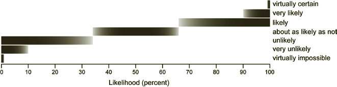
Figure P.1: Likelihood Terminology
3.7 Predictions: Potential Changes to the MidAtlantic Ocean Coast due to Sea Level Rise
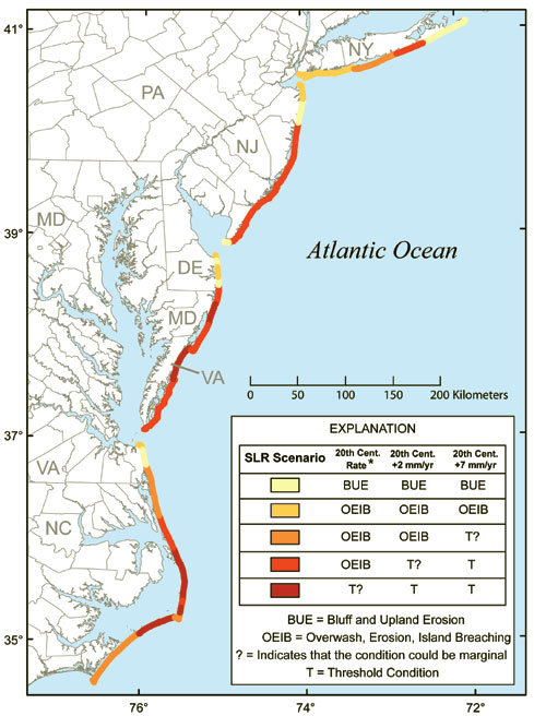
In this Section, the responses to the four sea-level rise scenarios considered in this Chapter are described according to coastal landform types (Figure 3.2). The four scenarios are:
- (1) a continuation of twentieth century rate of sea level rise;
- (2) the twentieth century rate plus 2 mm per year,
- (3) the twentieth century rate plus 7 mm per year; and
- (4) a 2-meter (6.6-foot) rise over the next few hundred years.
- This is a regional-scale assessment and there are local exceptions to these geomorphic classifications and potential outcomes;
- Given that some portions of the mid-Atlantic coast are heavily influenced by development and erosion mitigation practices, it cannot be assumed that current practices will continue into the future given uncertainties regarding the decision-making process that occurs when these practices are pursued; but,
- At the same time, there are locations where some members of the panel believe that erosion mitigation will be implemented regardless of cost.
3.7.1 Spits
For sea-level rise Scenarios 1 through 3, it is virtually certain that the spits along the mid-Atlantic coast will be subject to increased storm overwash, erosion, and deposition over the next century (see Figure 3.2, coastal compartments 4, 9, 15). It is virtually certain that some of these coastal spits will continue to grow through the accumulation of sediments from longshore transport as the erosion of updrift coastal compartments occurs. For Scenario 4, it is likely that threshold behavior could occur for this type of coastal landform (rapid landward and/ or alongshore migration).
Figure 3.2: Will barrier islands disintegrate as sea level rises?
3.7.2 Headlands
Over the next century, it is virtually certain that these headlands along the mid-Atlantic coast will be subject to increased erosion for all four sea-level rise scenarios (see Figure 3.2, coastal compartments 1, 5, 8, 10, 12, and 16). It is very likely that shoreline and upland (bluff) erosion will accelerate in response to projected increases in sea level.
3.7.3 Wave-Dominated Barrier Islands
Potential sea-level rise impacts on wave-dominated barriers in the Mid-Atlantic vary by location and depend on the sea-level rise scenario (see Figure 3.2, coastal compartments 2, 6, 11, 13, 17). For Scenario 1, it is virtually certain that the majority of the wave-dominated barrier islands along the mid-Atlantic coast will continue to experience morphological changes through erosion, overwash, and inlet formation as they have over the last several centuries, except for the northern portion of Assateague Island (coastal compartment 13). In this area, the shoreline exhibits high rates of erosion and large portions of this barrier are submerged during moderate storms. In the past, large storms have breached and segmented portions of northern Assateague Island. Therefore, it is possible that these portions of the coast are already at a geomorphic threshold. With any increase in the rate of sealevel rise, it is virtually certain that this barrier island will exhibit large changes in morphology, ultimately leading to the degradation of the island. At this site, however, periodic transfer of sand from the shoals of Ocean City inlet appear to Box 3.2). Portions of the North Carolina Outer Banks (Figure 3.2) may similarly be nearing a geomorphic threshold. For Scenario 2, it is virtually certain that the majority of the wave-dominated barrier islands in the mid-Atlantic region will continue to experience morphological changes through overwash, erosion, and inlet formation as they have over the last several centuries. It is also about as likely as not that a geomorphic threshold will be reached in a few locations, resulting in rapid morphological changes in these barrier systems. Along the shores of northern Assateague Island (coastal compartment 13) and a substantial portion of coastal compartment 17 it is very likely that the barrier islands could exhibit threshold behavior (barrier segmentation). For this scenario, the ability of wetlands to maintain their elevation through accretion at higher rates of sea-level rise may be reduced (Reed et al., 2008). It is about as likely as not that the loss of back-barrier marshes will lead to changes in hydrodynamic conditions between tidal inlets and back-barrier lagoons, thus affecting the evolution of barrier islands.
For Scenario 3, it is very likely that the potential for threshold behavior will increase along many of the mid-Atlantic barrier islands. It is virtually certain that a 2-meter (6.6-foot) sea-level rise will lead to threshold behavior (segmentation or disintegration) for this landform type.
3.7.4 Mixed-Energy Barrier Islands
The response of mixed-energy barrier islands will vary (see Figure 3.2, coastal compartments 3, 7, 14). For Scenarios 1 and 2, the mixed-energy barrier islands along the mid-Atlantic will be subject to processes much as have occurred over the last century such as storm overwash and shoreline erosion. Given the degree to which these barriers have been developed, it is difficult to determine the likelihood of future inlet breaches, or whether these would be allowed to persist due to common management decisions to repair breaches when they occur. In addition, changes to the back-barrier shores are uncertain due to the extent of coastal development.
It is about as likely as not that four of the barrier islands
along the Virginia Coast (Wallops, Assawoman, Metompkin,
and Cedar Islands) are presently at a geomorphic
threshold. Thus, it, it is very likely that further sea-level
rise will contribute to significant changes resulting in the
segmentation, disintegration and/or more rapid landward
migration of these barrier islands.
For the higher sea-level rise scenarios (Scenarios 3 and 4),
it is about as likely as not that these barriers could reach a
geomorphic threshold. This threshold is dependent on the
availability of sand from the longshore transport system
to supply the barrier. It is virtually certain that a 2-meter
(6.6-foot) sea-level rise will have severe consequences along
the shores of this portion of the coast, including one or more
of the extreme responses described above. For Scenario 4,
the ability of wetlands to maintain their elevation through
accretion at higher rates of sea-level rise may be reduced. It is about as likely as not that the loss
of back-barrier marshes could lead to changes in the hydrodynamic
conditions between tidal inlets and back-barrier
lagoons, affecting the evolution of barrier islands.