- Coastal Elevations
- Ocean Coasts
- Vulnerable Species
- Societal Impacts
- Adaptation
- Elevation Maps
- Planning Maps
Coastal Wetland Sustainability
Related Links
U.S. Global Change Research Program
Other EPA-sponsored Climate Change Science Program Synthesis and Assessment Reports
By Don Cahoon, Denise Reed, and Others
Coastal Wetland Sustainability (14 pp, 8.6MB)
was originally published as
Chapter 4 of the US Climate Change Science Program's Synthesis and Assessment Product 4.1. A reasonable way of citing this paper would be:
Cahoon, D.R., D.J. Reed, A.S. Kolker, M.M. Brinson, J.C. Stevenson, S. Riggs, R. Christian, E. Reyes, C. Voss, and D.
Kunz, 2009. Coastal wetland sustainability.
In: J.G. Titus (coordinating lead author),
K.E. Anderson, D.R. Cahoon, D.B. Gesch, S.K. Gill, B.T. Gutierrez, E.R. Thieler, and S.J. Williams
(lead authors). Coastal Sensitivity to Sea-Level Rise: A Focus on the Mid-Atlantic Region.
U.S. Environmental Protection Agency, Washington DC, pp. 43-56.
The panel considered three sea level rise scenarios:
Key Findings

- It is virtually certain that tidal wetlands already experiencing submergence by sea-level rise and associated high rates of loss (e.g., Mississippi River Delta in Louisiana, Blackwater River marshes in Maryland) will continue to lose area in response to future accelerated rates of sea-level rise and changes in other climate and environmental drivers (factors that cause measurable changes).
- It is very unlikely that there will be an overall increase in tidal wetland area in the United States over the next 100 years, given current wetland loss rates and the relatively minor accounts of new tidal wetland development (e.g., Atchafalaya Delta in Louisiana).
- Current model projections of wetland vulnerability on regional and national scales are uncertain due to the coarse level of resolution of landscape-scale models. In contrast, site-specific model projections are quite good where local information has been acquired on factors that control local accretionary processes in specific wetland settings. However, the authors have low confidence that site-specific model simulations can be successfully generalized so as to apply to larger regional or national scales.
- An assessment of the mid-Atlantic region based on an opinion approach by scientists with expert knowledge of wetland accretionary dynamics projects with a moderate level of confidence that those wetlands keeping pace with twentieth century rates of sea-level rise (Scenario 1) would survive a 2 millimeter per year acceleration of sea-level rise (Scenario 2) only under optimal hydrology and sediment supply conditions, and would not survive a 7 millimeter per year acceleration of sea-level rise (Scenario 3). There may be localized exceptions in regions where sediment supplies are abundant, such as at river mouths and in areas where storm overwash events are frequent.
- The mid-Atlantic regional assessment revealed a wide variability in wetland responses to sea-level rise, both within and among subregions and for a variety of wetland geomorphic settings. This underscores both the influence of local processes on wetland elevation and the difficulty of generalizing from regional/national scale projections of wetland sustainability to the local scale in the absence of local accretionary data. Thus, regional or national scale assessments should not be used to develop local management plans where local accretionary dynamics may override regional controls on wetland vertical development.
Panel Findings
The panel developed an approach for predicting wetland response to sea-level rise that was more constrained by available studies of accretion and accretionary processes in some areas of the mid-Atlantic region (e.g., Lower Maryland Eastern Shore) than in other areas (e.g., Virginia Beach/ Currituck Sound). Given these inherent data and knowledge constraints, the authors classified the confidence level for all findings in Reed et al. (2008) as likely (i.e., greater than 66 percent likelihood but less than 90 percent).
Figure 4.4 presents the panel’s consensus findings on wetland vulnerability of the mid-Atlantic region. The panel determined that a majority of tidal wetlands settings in the mid-Atlantic region (with some local exceptions) are likely keeping pace with Scenario 1, that is, continued sea-level rise at the twentieth century rate, 3 to 4 mm per year (areas depicted in brown, beige, yellow, and green in Figure 4.4) through either mineral sediment deposition, organic matter accumulation, or both. However, under this scenario, extensive areas of estuarine marsh in Delaware Bay and Chesapeake Bay are marginal (areas depicted in red in Figure 4.4), with some areas currently being converted to subtidal habitat (areas depicted in blue in Figure 4.4). It is virtually certain that estuarine marshes currently so converted will not be rebuilt or replaced by natural processes. Human manipulation of hydrologic and sedimentary processes and the elimination of barriers to onshore wetland migration would be required to restore and sustain these degrading marsh systems. The removal of barriers to onshore migration invariably would result in land use changes that have other societal consequences such as property loss.
Under accelerated rates of sealevel rise (Scenarios 2 and 3), the panel agreed that wetland survival would very likely depend on optimal hydrology and sediment supply conditions. Wetlands primarily dependent on mineral sediment accumulation for maintaining elevation would be very unlikely to survive Scenario 3, (i.e., at least 10 mm per year rate of sea-level rise when added to the twentieth century rate). Exceptions may occur locally where sediment inputs from inlets, overwash events, or rivers are substantial (e.g., back-barrier lagoon and lagoonal fill marshes depicted in green on western Long Island, Figure 4.4).
Environmental Setting of the Wetlands and Potential to Keep Up with Rising Sea Level

Source: Wetland Accretion Maps created by Titus, Jones, and Streeter (2008) based on the panel assessment, further documented in Reed et al. (2008)
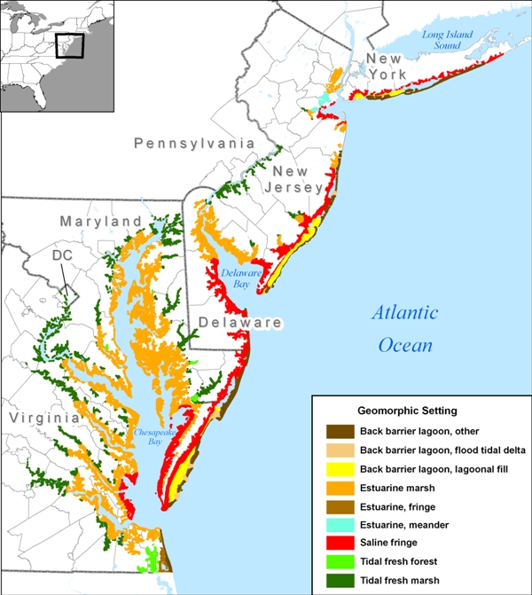
Wetland responses to sea-level rise are typically complex. A close comparison of Figure 4.3 and Figure 4.4 reveals that marshes from all geomorphic settings, except estuarine meander (which occurs in only one subregion), responded differently to sea-level rise within and/or among subregions, underscoring why local processes and drivers must be taken into account. Given the variety of marsh responses to sea-level rise among and within subregions, assessing the likelihood of survival for each wetland setting is best done by subregion, and within subregion, by geomorphic setting.
The scientific panel determined that tidal fresh marshes and forests in the upper reaches of rivers are likely to be sustainable (i.e., less vulnerable to future sea-level rise than most other wetland types), because they have higher accretion rates and accumulate more organic carbon than saline marshes. Tidal fresh marshes have access to reliable and often abundant sources of mineral sediments, and their sediments typically have 20 to 50 percent organic matter content, indicating that large quantities of plant organic matter are also available. Assuming that salinities do not increase, a condition that may reduce soil organic matter accumulation rates, and current mineral sediment supplies are maintained, the panel considered it likely that tidal fresh marshes and forests would survive under Scenario 3. Vertical development, response to accelerated sea-level rise, and movement into newly submerged areas are rapid for tidal fresh marshes. For several tidal fresh marshes in the high sediment-load Delaware River Estuary, vertical accretion through the accumulation of both mineral and plant matter ranged from 7 mm per year to 17.4 mm per year from the 1930s to the 1980s as tidal influences became more dominant. Exceptions to the finding that fresh marshes and forests would survive under Scenario 3 are the New Jersey shore, where tidal fresh marsh is considered marginal under Scenario 2 and lost under Scenario 3, and Virginia Beach–Currituck Sound where fresh forest is marginal under Scenario 1, marginal or lost under Scenario 2, and lost under Scenario 3.
Different marshes from the geomorphic settings back-barrier other, back-barrier lagoonal fill, estuarine marsh, and saline fringe settings responded differently to sea-level rise within at least one subregion as well as among subregions. For example, back-barrier lagoonal fill marshes on Long Island, New York were classified as either keeping pace or lost at the current rate of sea-level rise. Those marshes surviving under Scenario 1 were classified as either marginal (brown) or keeping up (beige and green) under Scenario 2 (Figure 4.4). Under Scenario 3, only the lagoonal fill marshes depicted in green in Figure 4.4 are expected to survive.
The management implications of these findings are important on several levels. The expert panel approach provides a regional assessment of future wetland resource conditions, defines likely trends in wetland change, and identifies areas of major vulnerability. However, the wide variability of wetland responses to sea-level rise within and among subregions for a variety of geomorphic settings underscores not only the influence of local processes on wetland elevation but also the difficulty of scaling down predictions of wetland sustainability from the regional to the local scale in the absence of local accretion data. Most importantly for managers, regional scale assessments such as this should not be used to develop local management plans because local accretionary effects may override regional controls on wetland vertical development. Instead, local managers are encouraged to acquire data on the factors influencing the sustainability of their local wetland site, including environmental stressors, accretionary processes, and geomorphic settings, as a basis for developing local management plans.
- For more reports focused on the implications of rising sea level, go to More Sea Level Rise Reports.

 Chapter 3: Ocean Coasts