- New Report
- Regional set of maps
- Georgia maps in zpped file
- Single County Planning Maps
- Shore Protection Methods
- Data
Governments Plan for Development of Land Vulnerable to Rising Sea Level: Georgia
Teresa Concannon et al. 2010. "Georgia". In The Likelihood of Shore Protection along the Atlantic Coast of the United States. Volume 2: New England and South Atlantic. Edited by James G. Titus, Daniel L. Trescott, and Daniel Hudgens. Report to the U.S. Environmental Protection Agency.
The summary is on this page. You can also download a printer quality version of this Georgia sea level rise planning study (pdf 4 MB).
Summary
The ocean coast of Georgia is mostly developed with single family homes, although a few communities have low-rise condominiums. Several barrier islands, however, are undeveloped either because they are conservation land. The Georgia coasta also has gated communities that are entirely closed to the public. The lack of public access makes these islands ineligible for publicly funded shore protection-but these communities generally have very high property values which could justify privately funded beach nourishment.
The land potentially submerged by rising sea level extends tens of miles inland from the ocean. Most of this land is still rural, like the Carolinas but in stark contrast with Florida and the Atlantic coast from New Jersey northward. Inland areas near the major beach resorts or the cities of Savanah or Brunswick are being developed-but development is not anticipated for many coastal areas.
Our efforts to map the likelihood of shore protection in Georgia is based on a set of county-specific studies conducted for the US Envirnmental Protection Agency several few years ago by the Coastal Georgia Regional Development Center but never published. We updated that study by obtaining recent data layers and by consulting with county planners about prospects for additional development. For Chatham County, all private coastal lands are expected to be developed (and protected) unless there was a specific reason for not expecting development, such as conservation easements, being part of a nature reserve. The other counties generally do not have plans that identify all areas where development is eventually likely to take place. For those rural counties, we assumed that undeveloped areas are unlikely to be developed unless the county had an expectation of development--but recognize that the maps understate eventual development. Along estuaries, shore protection is almost certain for developed areas. Along the ocean, shore protection is almost certain for most developed areas, unless there was a reason for doubting shore protection, such as relatively sparse development, a very narrow barrier island, or lack of public access.
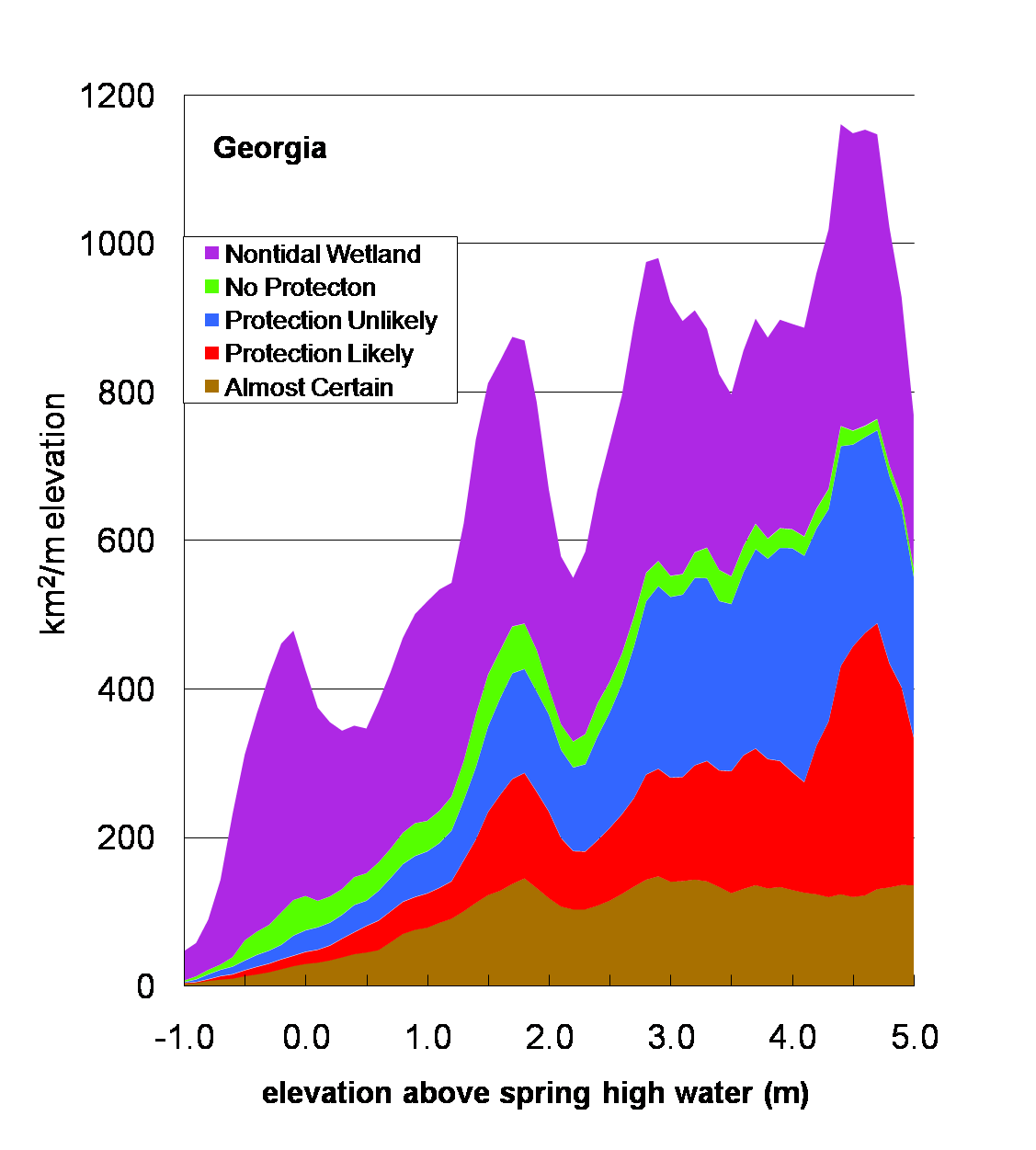
The accompanying chart shows the area of land in various classifications for each meter of elevation. For further details, please see county-specific summaries or the state-specific report by Concannon et al.
Governments Plan for Development of Most Land Vulnerable to Rising Sea (PDF, 7 pp., 1.3 MB) was originally published in Environmental Research Letters , Issue 3, Volume 4 (2009).