- New Report
- Regional set of maps
- SC maps in zipped file
- Single County Planning Maps
- Shore Protection Methods
- Data
Governments Plan for Development of Land Vulnerable to Rising Sea Level: South Carolina
Cheryl Matheny et al. 2010. "South Carolina". In The Likelihood of Shore Protection along the Atlantic Coast of the United States. Volume 2: New England and South Atlantic. Edited by James G. Titus, Daniel L. Trescott, and Daniel Hudgens. Report to the U.S. Environmental Protection Agency.
The summary is on this page. You can also download a printer quality version of this South Carolina planning study (pdf 3.5 MB, 139 pp).
Abstract
The ocean coast of South Carolina is mostly developed with single family homes, although Myrtle Beach has some areas with high-rises and several oceanfront communities have low-rise condominiums. Several barrier islands, however, are undeveloped either because they are conservation land or because there is not bridge connecting the island to the mainland. Unlike the mid-Atlantic and New England coasts, however, a significant part of the South Carolina coast is part of a gated community-several islands are entirely closed to the public. The lack of public access makes these islands ineligible for publicly funded shore protection-but these communities generally have very high property values which could justify privately funded beach nourishment.
The land potentially submerged by rising sea level extends tens of miles inland from the ocean. Most of this land is still rural, like Georgia and North Carolina but in stark contrast with most of the rest of the Atlantic coast. Inland areas near the major beach resorts or the cities of Charleston or Beaufort are being developed-but development is not anticipated for many coastal areas.
Our efforts to map the likelihood of shore protection in South Carolina is based on a set of county-specific studies conducted for EPA several years ago but never published. We updated that study by obtaining recent data layers and by consulting with county planners about prospects for additional development. For Horry County, all private coastal lands are expected to be developed (and protected) unless there was a specific reason for not expecting development, such as conservation easements, being part of a nature reserve, or the expectation of becoming part of a nature reserve. For the other counties, by contrast, we assumed that undeveloped areas are unlikely to be developed unless the county had an expectation of development. Along estuaries, shore protection is almost certain for developed areas. Along the ocean, shore protection is almost certain for most developed areas, unless there was a reason for doubting shore protection, such as relatively sparse development, a very narrow barrier island, or lack of public access.
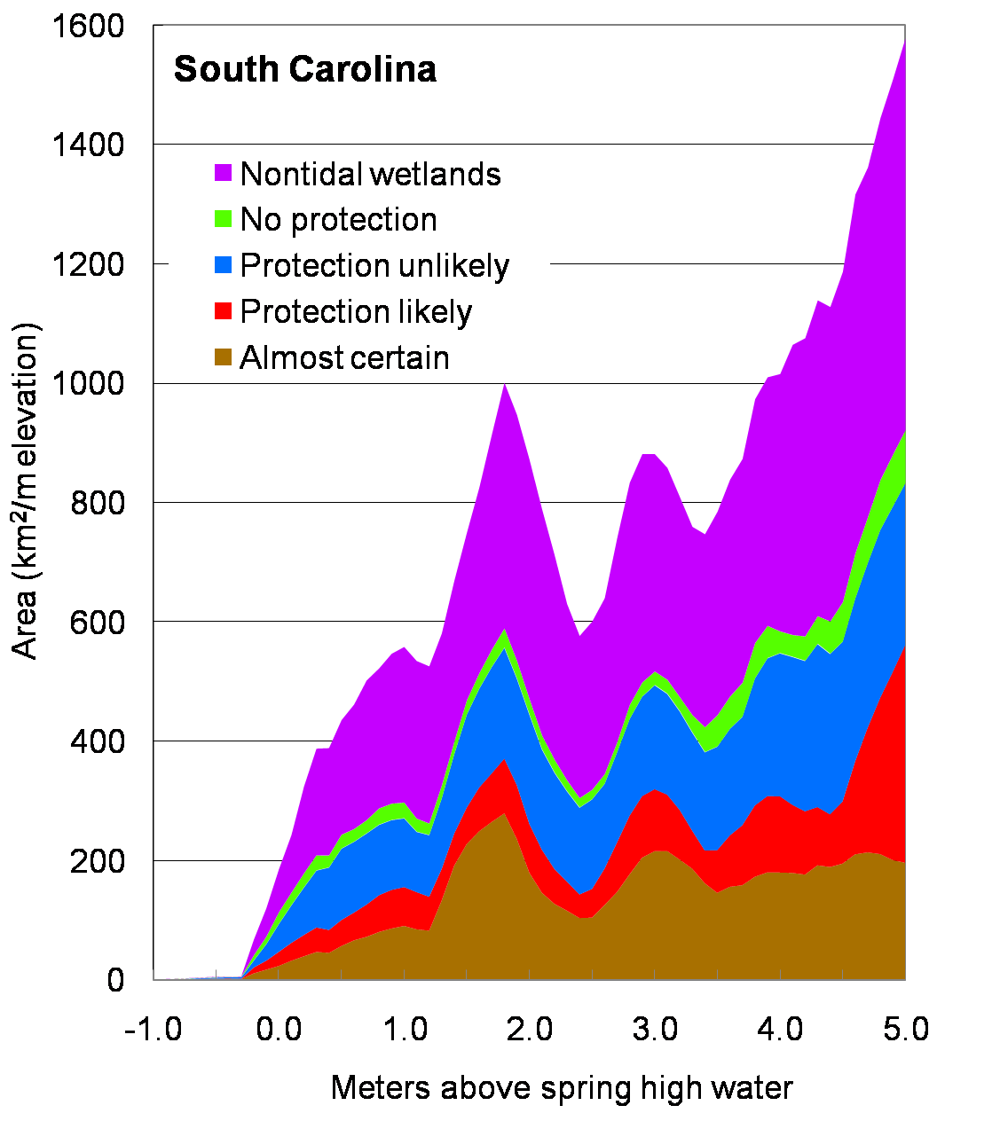
The accompanying chart shows the area of land in various classifications for each meter of elevation. For example, between 1 and 2 meters above spring high water, there is about 800 square kilometers of land, about 250 of which are nontidal wetlands. The area of land where shore protection is almost certain accounts for about half the dry land. For further details, please see summaries for Horry, Georgetown, Berkeley, Charleston, Colleton, Beaufort, and Jasper Counties.
Governments Plan for Development of Most Land Vulnerable to Rising Sea (PDF, 7 pp., 1.3 MB, was originally published in Environmental Research Letters , Issue 3, Volume 4 (2009).