- Causes of Future Sea Level Rise
- Elevation Maps
- Will we really lose all that land?
- Sea Level Rise Planning Maps
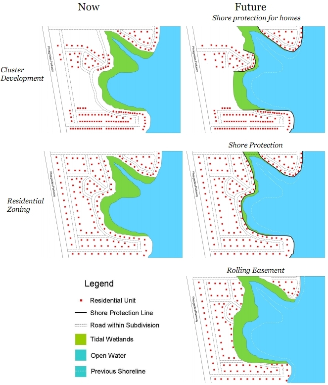
Cluster development is a common way to preserve open space, albeit on a much smaller scale than transferable development rights. Rather than convert a parcel to a subdivision with uniform density, a developer sets aside a portion of the land for a permanent park or preserve, while developing the rest of the parcel at a higher density.[1] Sometimes condominium apartment buildings, townhouses, or row houses are built on land that would otherwise have free-standing single-family homes, so that the development occupies a small fraction of the parcel. If the parcel is large enough, a cluster development can leave substantial land vacant for wetland migration—provided that a rolling easement is placed on the land that remains vacant as a result of the cluster. (See Figure 13.)
[1] Randall
Arendt, Basing Cluster Techniques on
Development Densities Appropriate to the Area, 63 Journal of the American Planning
Association 137–145 (1997). See
also Williamson County Regional Planning Comm'n v. Hamilton Bank of Johnson
City, 473 U.S. 172, 176–177 (1985) (discussing cluster
development).
This page contains a section from: James G. Titus, Rolling Easements, U.S. Environmental Protection Agency. EPA-430-R-11-001 (2011). The report was originally published by EPA's Climate Ready Estuary Program in June 2011. The full report (PDF, 176 pp., 7 MB) is also available from the EPA web site.
For additional reports focused on the implications of rising sea level, go to Sea Level Rise Reports.

 3.4.3 Landward Migration of Developed Barrier Islands
