- Causes of Future Sea Level Rise
- Elevation Maps
- Will we really lose all that land?
- Sea Level Rise Planning Maps
The potential impact of rising sea level on public access depends on how the public obtained access.
If the public trust doctrine is the source of public access, then the impact of sea level rise on access is similar to the impact on wetlands and beaches. Where there is no shoreline armoring or other obstruction, shoreline erosion causes the landward boundary of public access to move inland. Any seaward boundaries for specific types of access move inland as well: For example, if driving on the beach is prohibited within 50 feet inland of the high water mark, then as the shore erodes, that boundary will migrate inland. Similarly, pedestrian access is generally impractical seaward of the mean high tide line in areas of wave runup: as the shore erodes, the mean high tide line retreats as well. Wherever the shore is armored, pedestrian and vehicular access can be eliminated as the access ways are squeezed between the retreating shore and the shoreline armoring.
Wherever the public has access for reasons other than the public trust doctrine, shore erosion can eliminate access whether or not the shore is armored.
Public Trust Lands. Where property lines follow a shoreline, the rule for several centuries has been that the property lines advance or retreat whenever shores gradually advance or retreat.[65] The principal is generally known as the “law of accretion and reliction (sea level drop)” because the law originally evolved as courts decided cases between the King of England and waterfront landowners regarding the ownership of newly created lands.[66] But the same rule applies when the shore erodes, which is part of the rule’s justification.[67]
When the shoreline migrates suddenly, by contrast, the property line does not move, under the “law of avulsion.”[68] Although somewhat counterintuitive,[69] courts treat avulsion and accretion differently for several reasons. Originally all lands had fixed boundaries,[70] so when large areas of land suddenly appeared over what had been water, early courts had little reason to change the rule that what had been the King’s water was now the King’s land.[71] When the state fills a body of water to create land, the state owns that land under the law of avulsion,[72] although there may be provisions to ensure that the littoral landowner continues to have access to the water.[73] The courts in some states, however, view the new land as an artificial accretion and award it to the waterfront landowner.[74] Another example of avulsion would be a river changing course[75] or the sudden creation of an inlet through a barrier island. If one’s home is originally west of a channel, and a storm causes the channel to switch to a point west of the home, then under the law of avulsion the same person still owns the home (see Figure 4).
The law of avulsion has a clear rationale when land is created or a
channel switches, but the logic for the rule is not as clear in the case of a
sudden retreat of the shoreline. Most ocean beaches have had at least one storm
that caused substantial erosion since the land was originally transferred from
the government to a private landowner. If courts follow the doctrine of
avulsion, then boundaries remain out in the ocean at the location where they had
been before the avulsive storm. Finding such boundaries would be difficult.
Moreover, if the original intent of a land grant from a state (or the King) was
for the public to own the wet beach below the high water mark, it seems unlikely
that the state would want continued public ownership of the wet beach to depend
on whether shore erosion was caused by severe storms or more gradual
processes. For this reason,
Many states that observe the law of avulsion provide the waterfront land owner with the right to fill and thereby recover the lost dry land,[77] but eventually move the boundary inland if the owner fails to do so. The right to recover lost land has limited utility: Federal and state laws require a landowner to obtain a permit before filling open water or wetlands with soils to create or reclaim land from the sea, and obtaining such a permit may be difficult.[78] Nevertheless, the landowner’s right to reclaim land implies that when a governmental beach nourishment project reclaims the land shortly after it is lost, the reclaimed land belongs to the private landowner, though otherwise land created by beach nourishment would be an avulsion that belongs to the state.[79]
Access along Privately Owned Lands. As we discuss in the previous subsection, the public has access to many privately owned beaches, for one of two reasons: (a) under the public trust doctrine of a few states, the public retained access to the beach when the state (or King) transferred the land to a private owner or (b) the public re-acquired access from a private landowner. The impact of sea level rise on access along the shore is different for those two situations:
· The public access way reserved by the public trust doctrine migrates inland as shores erode.
· A public access way acquired from a private landowner does not migrate if that landowner’s parcel is submerged; so access along a beach can become impractical.
· The impact on access is ambiguous (depends on state-specific law and site-specific facts) if public access is acquired from a private landowner and only a portion of her parcel is submerged.
Under the public trust doctrine, the inland boundaries of public
access are based on environmental features of the shore. Therefore, when the
shoreline moves gradually, the inland boundary of public access also moves. In
Public access usually does not migrate inland where it has been obtained by means other than the public trust doctrine. As a general rule, a landowner can grant someone else the right to cross her own land. (Such a right is generally called an “easement.” Chapter 3 discusses easements in greater detail.[83]) But a waterfront owner cannot sell what she does not own, such as the right to cross a neighbor’s land. Therefore, the dry beach easement conveyed by the owner of one parcel cannot migrate to an inland parcel. Consider the many communities where government agencies have purchased or otherwise acquired public access along privately owned beaches whose title extends to mean high water. The public access is along beaches over parcels that are waterfront today, but not across parcels that are not even along the water. Suppose the shore erodes so that today’s beaches become water and the beach migrates onto land that currently is the second row of lots back from the ocean. The public will not have access along the new dry beach.[84] It will still have access across land that was previously the dry beach; but pedestrian access will not be feasible if the mean high tide line is regularly flooded by the runup from large waves.
There is no clear rule about whether existing public easements
migrate inland within a given parcel of land.[85] If the normal
rule for easements applies, then the inland boundaries probably do not move
inland.[86] Some state courts
have explicitly declared that easements do not roll.[87] In
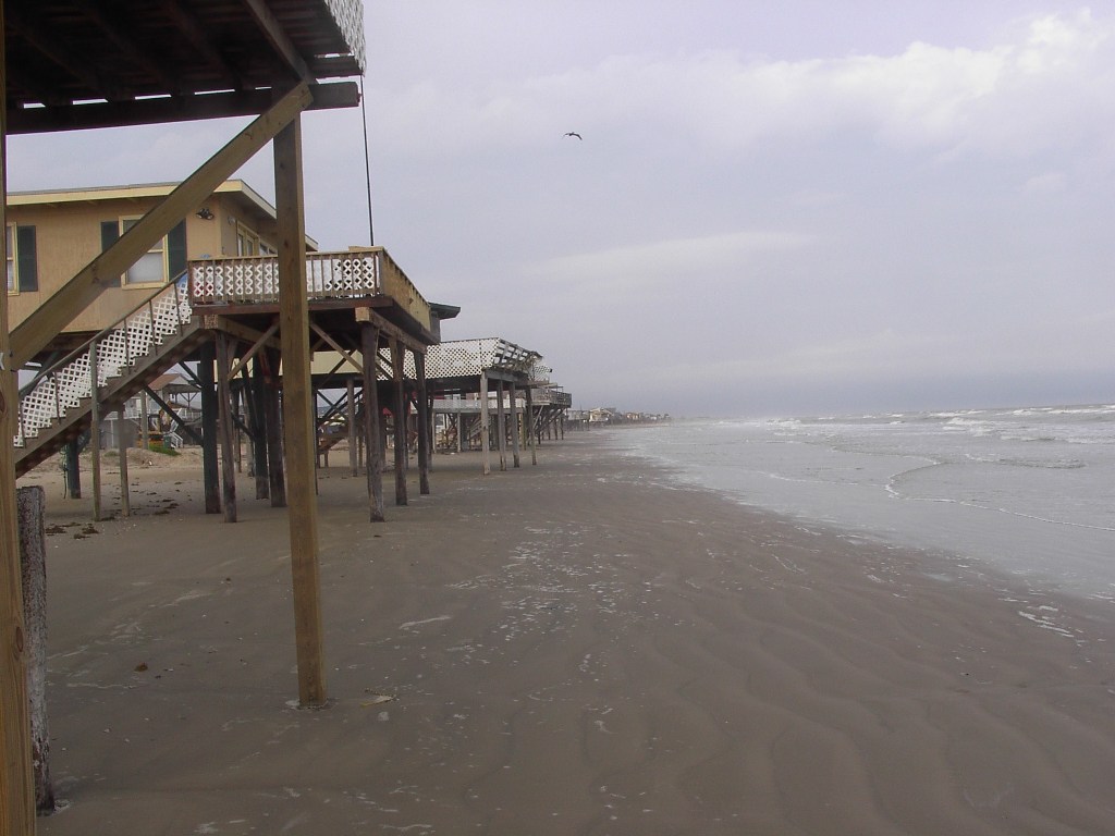
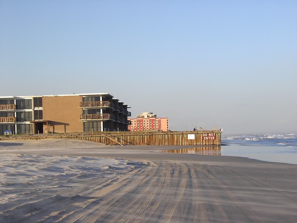
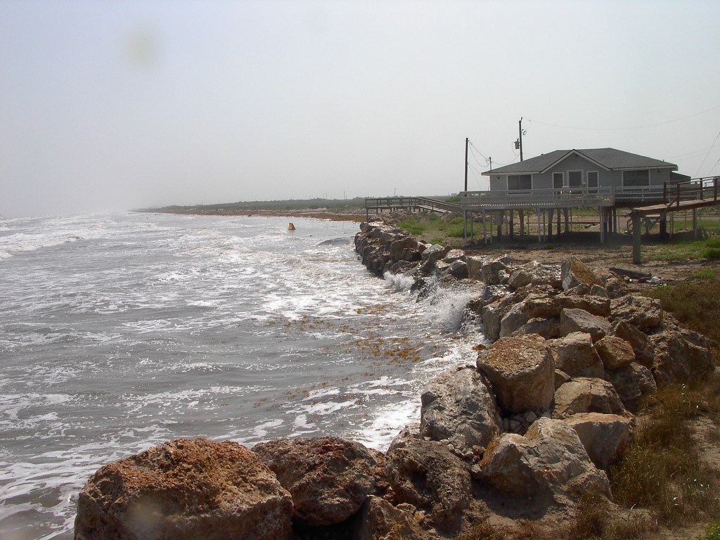
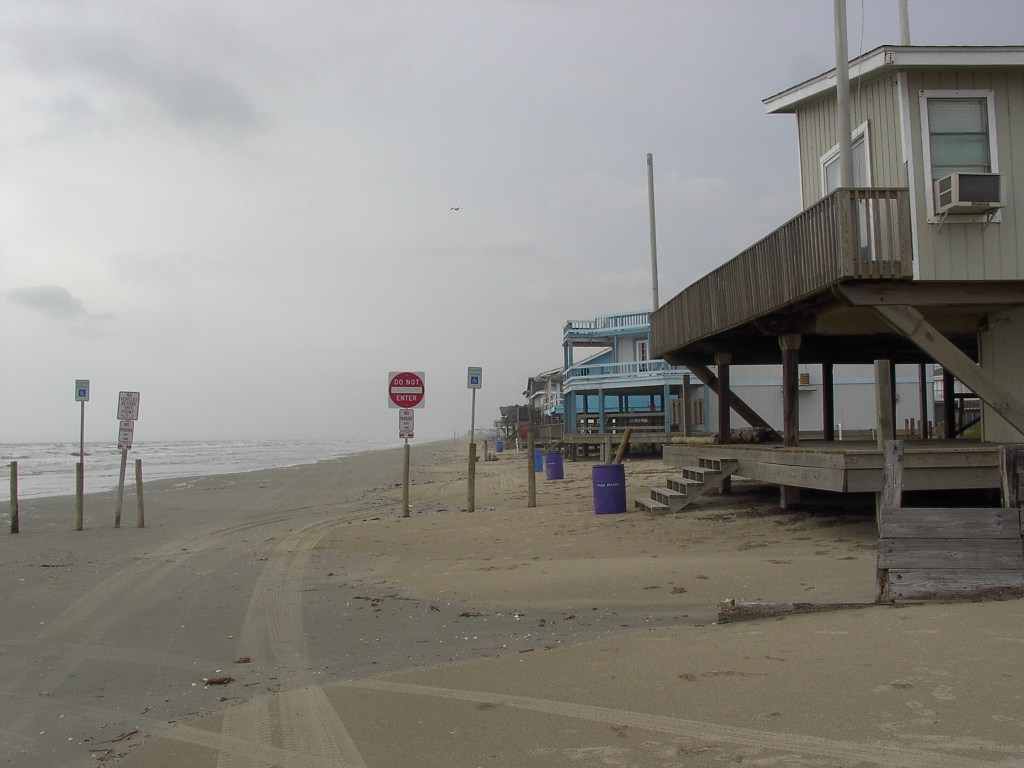
Shoreline Structures. Homes standing on the beach can impair access along the shore, by blocking vehicles and creating a hazard to anyone on the beach (see Photos 14 and 15). Where the shore is armored , pedestrian and vehicular access along an eroding shore is generally lost because the beach is eliminated (see Photos 16 to 18).[89]
|
|
 |

|

|

|
Photos 16 to 18. Shoreline armoring can make vehicular and pedestrian access along the shore impractical. Top left: a seawall protecting some high-rise buildings along the Gulf of Mexico on North Padre Island prevents automobile traffic on the beach (March 2010). Top right: At first, traffic was restricted to one-way (March 1998). Bottom: a stone revetment makes walking along the shore impractical north of Surfside, Texas (May 2003). Photo source: ©James G. Titus, used by permission. |
[65] See J.L. Sax, Changing Currents: Perspectives on the State
of Water Law and Policy in the 21st Century: The Accretion/Avulsion Puzzle: Its
Past Revealed, Its Future Proposed,
23 Tulane Environmental
Law Journal 305,
306 (2010). See also County of St.
Clair v. Lovingston, 90 U.S. (23 Wall.) 46, 66–69 (1874) (quoting the Institutes
of Justinian, Code Napoleon, and Blackstone for the universal rule that a
boundary shifts with the shore). In
England, three 14th century cases established the rule that gradual
accretions of land belong to the waterfront landowner: The Eyre of Nottingham Case (1348), The
Abbot of Peterborough’s Case (1367), and the Abbot of Ramsay’s Case (1369). Sax at
313–320.
[66]
See Sax, supra note 65,
at 313–334.
[67] “’Every
proprietor whose land is thus bounded is subject to loss by the same means which
may add to his territory, and as he is without remedy for his loss in this way
he cannot be held accountable for his gain.’” Lovingston, 90 U.S. (23 Wall.) at
68 (quoting Mayor of New Orleans v. United States, 35 U.S. (10 Pet.) 662, 717
(1836)).
[68] See, e.g., Stop the Beach Renourishment,
Inc. v. Florida Department of Environmental Protection, 130 S. Ct. 2592, 2611–2612, 560 U.S.
__, __–__ 2010 (discussing the Florida law of avulsion) and City of Long Branch
v. Liu, 833 A.2d 106, 363 (N.J. Super.
2003), aff’d City of Long Branch v. Jui Yung Liu, No. A-9 (N.J. 2010) (holding that
beach nourishment
does not change title from the state to the littoral landowner).
[69] Stop the Beach Renourishment, Inc. v.
Florida Department of Environmental Protection, 130 S. Ct. at 2612
560 U.S.
at
__ 2010
(“The result under
Florida law may seem counter-intuitive. After all … property has been deprived
of its character (and value) as oceanfront property by …an
avulsion.”).
[70] Professor Joe
Sax pointed out that in the common law, property originally had fixed boundaries
whether or not it was along the shore.
Sax, supra note 65,
at 311. When the king granted
property up to the shore, that meant up to where the shore was at the time of
the grant. As the law evolved, courts adopted the idea that boundaries move with
a slowly eroding or accreting shore (rule of accretion), in part because
awarding narrow and slowly evolving strips of land to the crown seemed
inefficient. Id. at 341–343. But the
old rule of fixed boundaries was not changed for those cases where the King
filled open water to create land or other cases where the creation of land was
abrupt (avulsion), because the reasons for the newer rule of accretion did not apply
to avulsion. Id. at 322,
325 & 342–43.
[71] Id. at 321 (“’[T]he ground which was the King’s
when it was covered with the waters, is his also when the waters have left it’”
(quoting The Readings of the Famous and
Learned Robert Callis, Esq, Upon the Statute of Sewers, 23 Hen. VIII c.5, as it
was Delivered by Him at Gray’s Inn, in August 1622 (4th
edition, William John Broderip, 1824))).
[72] See, e.g., Stop the Beach Renourishment,
Inc. v. Florida Department of Environmental Protection, 130 S. Ct. 2592, 2611–2612, 560 U.S.
__, __–__ (2010) (discussing the Florida law of
avulsion) and City of Long Branch v.
Liu, 833 A.2d 106, 363 (N.J. Super.
2003), aff’d City of Long Branch v. Jui Yung Liu, No. A-9 (N.J. 2010) (beach nourishment
does not change title from the state to the littoral landowner). Cf. New Jersey v. New York, 523 U.S. 767 (1998) (holding that
portions of Ellis Island created by filling the Hudson River are in New
Jersey because the island is within
the New Jersey side of the river and the doctrine of avulsion applies to
boundaries between sovereigns).
[73] Walton County v. Stop Beach
Renourishment, 998 So.2d 1102,
1119–1120 (Fla. 2008), aff’d Stop the Beach Renourishment,
Inc. v. Florida Department of Environmental Protection, 130 S. Ct. 2592, 560
U.S. __, (2010) (discussing Florida waterfront access rights, and how the
Florida Beach and Shore Preservation Act preserves the those rights).
[74] E.g., 342 Mass. 251, 173 N.E.2d 273 (1961) Benjamin
Michaelson & others v. Silver Beach Improvement Association, Inc., Supreme Judicial Court of
Massachusetts, Barnstable (land created by filling shallow waters as part of a
navigation project belongs to private landowner not the state)
and
State v. Gill,
66 So.2d 141, 142–43 (1953) (same).
[75] “Where a
stream, which is a boundary, from any cause suddenly abandons its old and seeks
a new bed, such change of channel works no change of boundary; and that the
boundary remains as it was, in the centre of the old channel, although no water
may be flowing therein. This sudden and rapid change of channel is termed, in
the law, avulsion.” Nebraska v. Iowa, 143 U.S.
359, 361 (1892).
[76] City of
Corpus Christi v. Davis, 622 SW 2d 640 (Tex. App. 1981) (concluding that the
doctrine of avulsion should not be applicable to eroding Gulf Coast Beaches but
declining to adopt such a holding because it is a matter more appropriately
addressed by the Texas Supreme Court). Severance v Patterson, No.
09-0387 (Tex. 2010). (“This
holding shall not be applied to use the avulsion doctrine to upset the
long-standing boundary between public and private ownership at the mean high
tide line. That result would be unworkable,
leaving ownership boundaries to mere guesswork. The division between public and
private ownership remains at the mean high tide line in the wake of naturally
occurring changes, even when boundaries seem to change suddenly”).
[77] See, e.g., Md. Code
Environment §16-201(a) (preserving right to reclaim land lost to
shoreline erosion since January 1, 1972); and Walton County v. Stop Beach Renourishment,
998 So.2d 1102, 1117 (Fl. 2008) (“Significantly, when an avulsive event
leads to the loss of land, the doctrine of avulsion recognizes the affected
property owner's right to reclaim the lost land within a reasonable
time.”). See generally 1 Henry Philip Farnham, The Law of Waters and Water
Rights § 74 at 331 (1904). This common law rule dates back at least
to the 17th century writings of England’s Lord Chief Justice Robert
Hale. “If a subject hath land adjoining the sea, and the violence of the sea
swallow it up, but so that yet there be reasonable marks to continue the notice
… [and] if it be by art or industry regained, the subject does not lose his
propriety, and so it was held … though the inundation continue forty years.”
Robert Hale, De Jure Maris, in Stuart A. Moore, A History of the Foreshore and
the Law Relating Thereto, 3d ed. 1888, at 381 (citing Cooke and
Foster, M. 7 Jac. C.
B.).
[78]
See generally CCSP, supra note 3,
at 147–149 and 166–168 (discussing tidal wetland protection regulations with a
focus on adapting to sea level rise).
[79]
See, e.g., Dept. of Natural Resources v. Ocean
City, 274 Md. 1, 14–15 (1975).
[80] See
Matthews v. Bay Head Improvement Ass'n, 471 A.2d 355, 358 (N.J. 1984)
(holding that
public trust access
includes the dry beach between mean high water and the vegetation line). State
ex rel. Thornton v. Hay, 462 P.2d 671, 672–74 (Or. 1969) (holding that
under the doctrine
of custom, public access extends inland to the 16-foot contour, which is similar
to the dune vegetation line).
Whether public access derived from the doctrine of custom migrates inland
is unclear. See infra note 85.
[81]
See supra note 54.
[82]
Courts have distinguished the impact of avulsion
on the boundary of tideland from access created for reasons other than the
public trust doctrine. See, e.g.,
Severance v
Patterson, No. 09-0387 (Tex.
2010).
[83] See infra §
3.2.2.1.
[84] This question
could be more complicated if access is
acquired when
waterfront parcels are large, and the parcel is subsequently subdivided. If the owner conveys an easement for
public access along the dry sand beach with language indicating an intent for
the easement to migrate, then such an easement will apply to the entire parcel,
even if it is subdivided.
[85] Trepanier v.
County of Volusia, 965 So.2d 276, 292–293 (Fla. App. 2007) (holding that
public easement
resulting from custom does not
migrate inland
if
evidence
does
not show that
people have customarily shifted their use
of the beach inland as the shore erodes).
[86] “Easement
boundaries are generally static and attached to a specific portion of private
property.” Severance v Patterson, No.
09-0387 (Tex. 2010). “As a general rule, once the location of
an easement has been established, neither the servient estate owner nor the
easement holder may unilaterally relocate the servitude." Id. (quoting Jon W. Bruce & James W. Ely, Jr., the Law
of Easements and Licenses in Land § 7:13 at 7-30 (2009)). See also P. Burka, Shoreline Erosion: Implications for Public
Rights and Private Ownership, 1 Coastal Zone Management Journal 175, 182
(1974) (arguing that public easements along the shore would not migrate inland,
with the possible exception of those reserved under the public trust doctrine).
But cf. infra notes 414–418
and accompanying text (suggesting that some courts place a higher priority on
achieving the intent of the parties who negotiated the easement than the specific route
that the easement holder uses to cross).
[87]
Smith v. Bruce, 241 Ga. 133, 147 (1978) (“Once an
easement in a specific area is conveyed to lot owners in a beach subdivision as
a beach or recreational area, or such an area has been offered for dedication
for public use and accepted by the public for such use it may, nevertheless, be
lost by gradual erosion and avulsion.)
[88]
“Texas does not recognize a ‘rolling’ easement on Galveston's West Beach.
Easements for public use of private dry beach property do change along with
gradual and imperceptible changes to the coastal landscape. But, avulsive events
such as storms and hurricanes that drastically alter pre-existing littoral
boundaries do not have the effect of allowing a public use easement to migrate
onto previously unencumbered property.” Severance v Patterson, No. 09-0387
(Tex. 2010).
This page contains a section from: James G. Titus, Rolling Easements, U.S. Environmental Protection Agency. EPA‑430‑R‑11‑001 (2011). The report was originally published by EPA's Climate Ready Estuary Program in June 2011. The full report (PDF, 176 pp., 7 MB) is also available from the EPA web site.
For additional reports focused on the implications of rising sea level, go to Sea Level Rise Reports.

 2.2.1 Existing access along the shore

