- New Report
- Regional set of maps
- All the Maps in Zipped File
- Single County Planning Maps
- Shore Protection Methods
- Data
Governments Plan for Development of Land Vulnerable to Rising Sea Level: Coastal Bend, Texas
Excerpts from Report by Texas Sea Grant
Calhoun County
The mainland Calhoun County (see map) is sandwiched between two major bays: San Antonio to the southwest and Matagorda to the northeast. The major developed areas are currently near the Bay cities of Port Lavaca, Seadrift, Point Comfort, and Port O'Conner. The majority of the inland area consists of agricultural land with emergent wetlands predominant along the coast of Espiritu Santo Bay, which separates the mainland from Matagorda Island. Emergent and woody wetlands line the large floodplain where the San Antonio and Guadeloupe Rivers merge at Greens Lake. Virtually all of Matagorda Island is contained within Matagorda Island State Park, and all of it is covered by CBRA, and thus unlikely to see development anytime soon.
Calhoun County has much less coastal development than most of the Texas coast, but it is poised for significant new growth. Prominent properties, such as the Powderhorn Ranch, have changed hands once or twice in the past few years, indicating the beginnings of some land speculation. Several new waterfront developments are underway near Sea Drift and Port O'Connor, as well as near Port Lavaca and Point Comfort. Calhoun County is in an attractive location, and if overall population trends continue as forecast in Texas, then there is good reason to believe Calhoun County could be a likely center for coastal development.
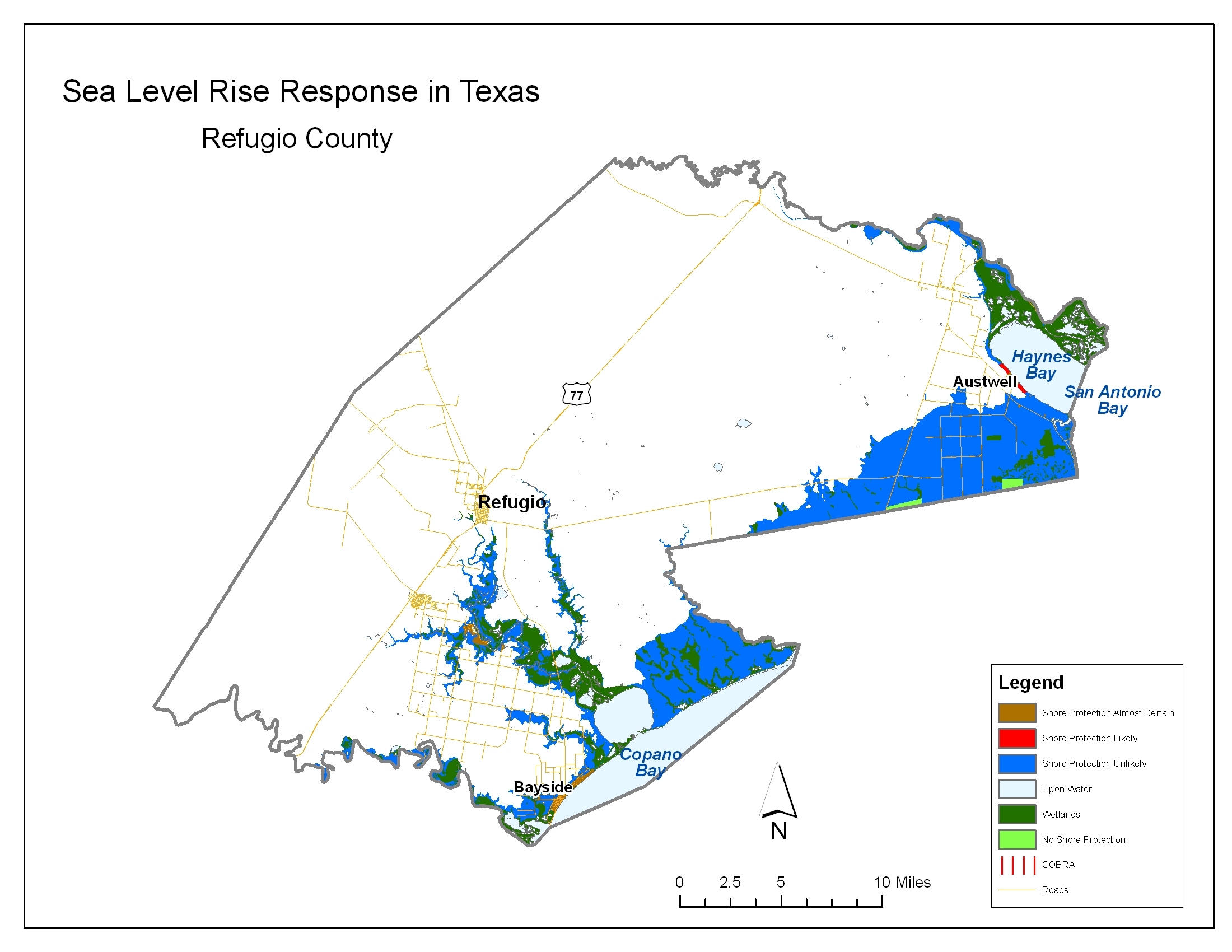
Refugio County
Refugio County (see map) borders Copano Bay to the southwest and San Antonio Bay to the northeast. The City of Refugio, outside our study area, is largest city in the county. The northern sections of the County include several large oil fields; agriculture and shrub lands dominate the southern part of the county.
Much of Refugio County is occupied by very large landholdings associated with the O'Connor and Welder families. These families apparently have little interest in converting their land to resort or other residential properties.
The town of Bayside occupies most of the developable land on the west side of Copano Bay. This community could be redeveloped into a resort community in the future, making shore protection even more likely, but the community already has sufficient density to justify shore protection The rest of Copano Bay is unlikely to become developed either because adjacent estuarine wetlands make it less attractive for recreational development or because it is part of the the large estates. Some development is likely along Haynes Bay near Austwell.
Aransas County
Aransas County (see map) is a small low-lying county largely surrounded by water. Most land in the county is either developed or within an area where development is unlikely for the foreseeable future. Along the Gulf of Mexico, San Jose Island is privately owned and used primarily as ranch land. Were it not part of the CBRA area is would be prime land for development, given its proximity to Rockport. No development is foreseen on this island under current conditions, so shore protection is unlikely for the foreseeable future.
The northeastern section of the County is within Aransas National Wildlife Refuge, and hence shore protection would be precluded for the Blackjack Peninsula. Deciduous forests are abundant within this Refuge. A few estuarine wetlands still line the northern banks of St. Charles Bay south of the refuge and the Bay side of San Jose Island. Relatively little agricultural land still exists in Aransas County. But Lamar Peninsula to the west is undergoing rapid development. The proximity to water and a world-class wildlife refuge are major draws for retirees and others. Therefore, we expect the southern half of Lamar Peninsula to become developed.
To the south, Rockport and Fulton are the largest incorporated cities in the county, with extensive unincorporated development lining Aransas Bay on Live Oak Peninsula. Current trends indicate that little open space will be left on Live Oak Peninsula. Some additional new development is also likely along the west side of Port Bay and the southwest side of Copano Bay.
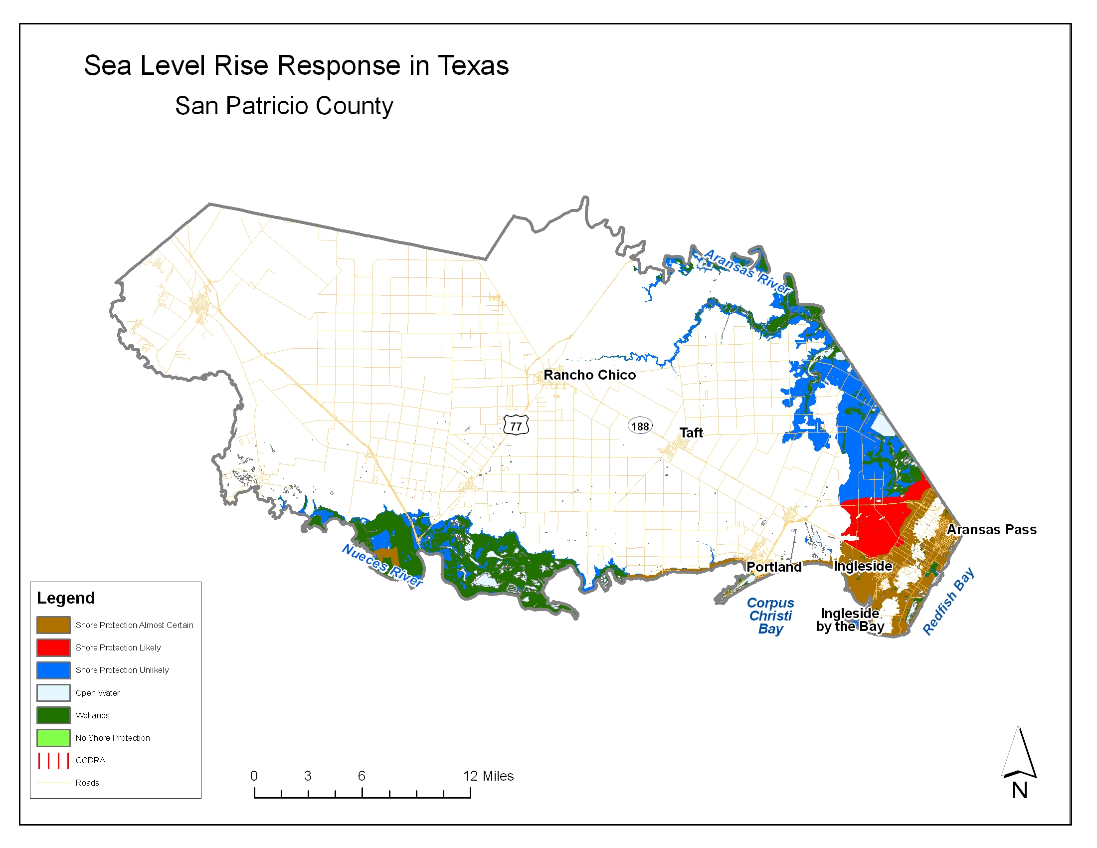
San Patricio County
San Patricio County (see map) is largely agricultural. The majority of development resides along the bays and coastal areas. The Nueces River, which drains into Corpus Christi Bay, has an extensive floodplain which contains a significant amount of wetlands, and development is precluded by flood hazad regulations.
All of the developable shoreline in San Patricio County appears to be at least moderately developed and therefore shore protection is almost certain. Almost all of the area along Redfish Bay has been converted to development. East and west of Portland, not much more than the shoreline itself is developed, and mainly only a single line or two of beach homes. Little development exists to the east of Portland, but our informants believe beach homes are imminent in this area. Most of the new development will be along the sandy ridge of land that extends from Ingleside up into the Live Oak Peninsula and Rockport. Some of the expansion associated with Rockport and Fulton are likely to ppill over into San Patricio County.
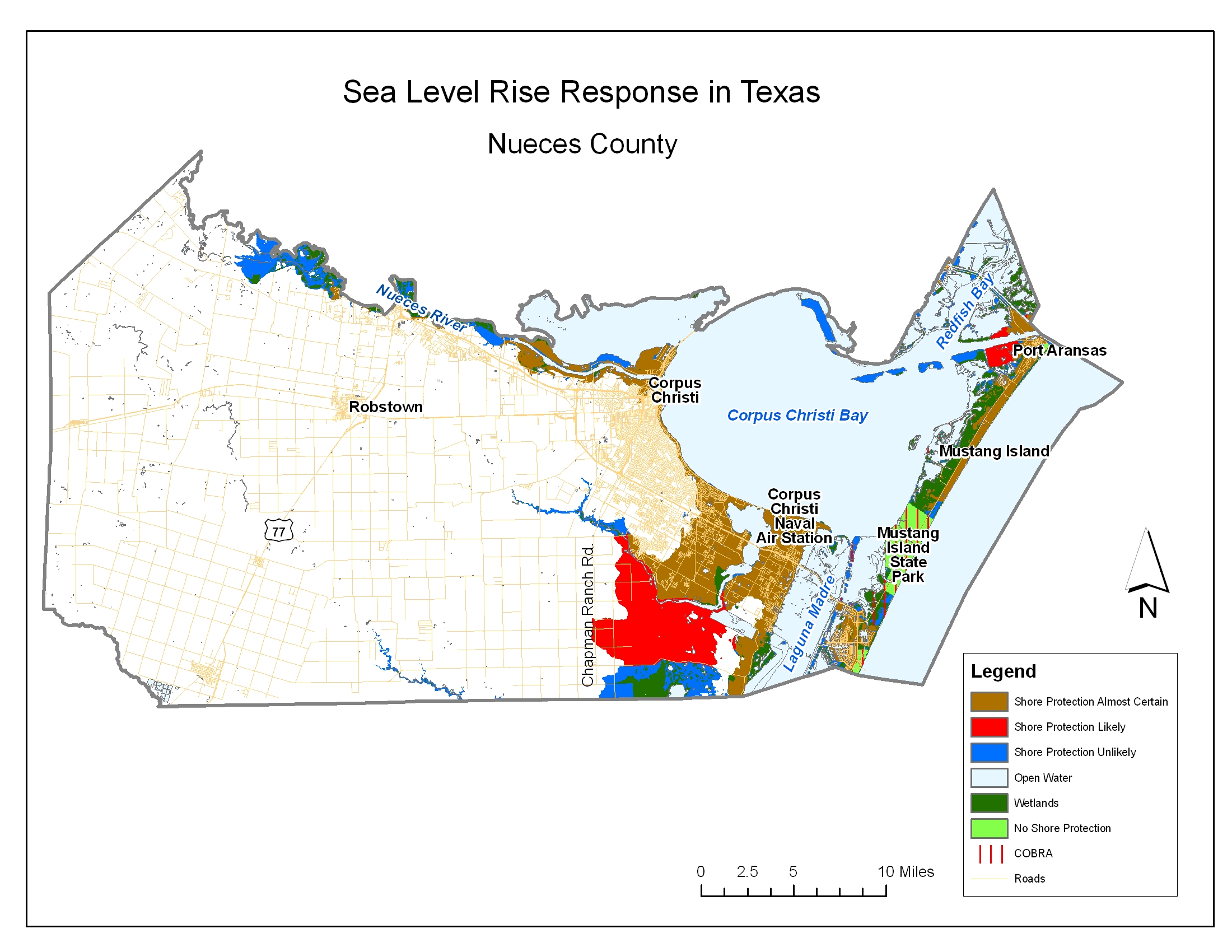
Nueces County
The Nueces County (see map) Gulf coast includes Mustang Island and the northern tip of Padre Island. About one third of Mustang Island is within Mustang Island State Park and hence off limits to both development and shore protection. The privately owned lands, however, are partly developed and are likely to be entirely developed in the coming decades. Although most of the coast is subject to a rolling easement, a seawall protects some high-rise buildings along the gulf near the northern end of the Padre Island. Although that seawall is exempt from the rolling easement, the public has been guaranteed pedestrian access along a roadway at the top of the wall.
Given the expectations for continued development, the Gulf coast of Nueces County is almost certain to be protected, except for Mustang Island State Park, with one possible exception. There is an upland area of potentially developable land just south of Mustang Island State Park that is currently undeveloped. This strip of land is covered by the Coastal Resources Barrier Act, and hence development is less imminent than on adjacent insurable coastal properties. Because there is road access, however, development will probably occur once the adjacent insurable lands have been developed. Even then, however, these lands will be ineligible for federal shore protection and the Texas Open Beaches Act would preclude privately funded seawalls. Therefore, we view this small area as unlikely to be protected.
Most of the Nueces county shoreline along Corpus Christi Bay and Laguna Madre are already extensively developed. The City of Corpus Christi occupies much of the bay waterfront, and refineries are found to the west and along the mouth of the Nueces River. Upstream the rivers from the refineries, there are still extensive wetlands and an undeveloped floodplain where development and shore protection are unlikely.
There is only a small amount of acquirable land within the study area south of Oso Creek. King Ranch owns the majority of the land east of Chapman Road and south of Oso Creek and extending to Laguna Madre, which limits future development to the south-east along Laguna Madre. Hence we show most land south of Oso Creek as unlikely to be protected.
Governments Plan for Development of Most Land Vulnerable to Rising Sea (PDF, 7 pp., 1.3 MB, was originally published in Environmental Research Letters , Issue 3, Volume 4 (2009).