- New Report
- Regional set of maps
- All the Maps in Zipped File
- Single County Planning Maps
- Shore Protection Methods
- Data
Governments Plan for Development of Land Vulnerable to Rising Sea Level: Laguna Madre and Padre Island, Texas
Excerpts from Report by Texas Sea Grant
South of Corpus Christi, both the Gulf Coast and the bay shores are undeveloped with little immediate prospects for development. Padre Island National Seashore occupies all of North Padre Island south of Corpus Christi, and large ranches with little prospects for development occupy the mainland. At the very southern end of Texas, however, a large portion of South Padre Island is intensively developed, and the mainland is being developed as well. Along both sides of Laguna Madre, development is gradually proceeding north.
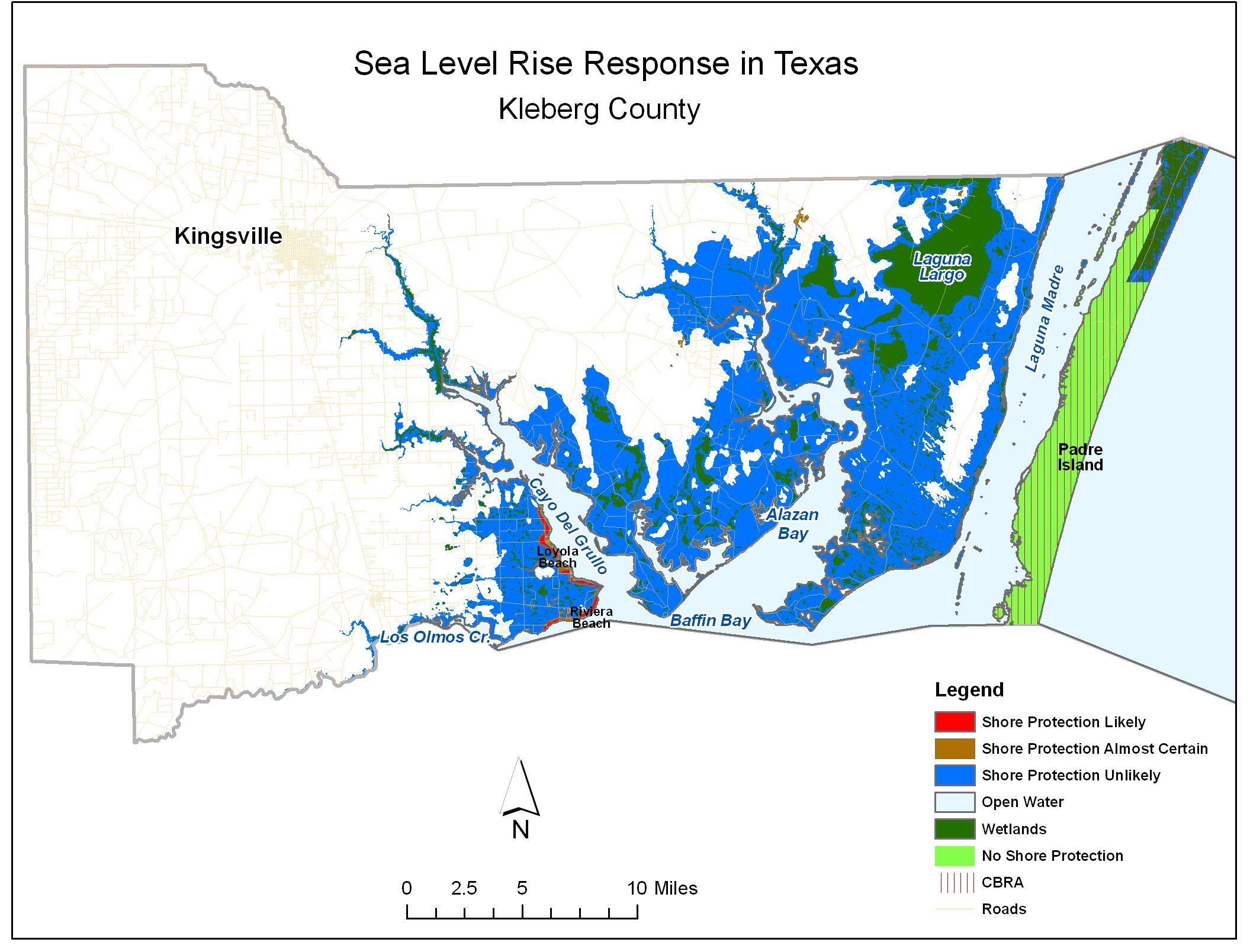
Kleberg County
Kingsville is the major population center of Kleberg County (see map), and it is well inland. All of Kleberg's Gulf Coast is within Padre Island National Seashore.
The towns of Riviera and Loyola Beach lie along the northern coast of Cayo Del Grullo, which flows into Baffin Bay, in the southern portions of the county. The coastal zone of Kleberg County is dominated by large ranches, particularly in the 20-ft elevation zone. There is no indication that any of the ranch owners wish to sell or develop their land.
There is a small area of private holdings, not in the large ranches, on the waterfront between Riviera and Loyola. No one has indicated an expectation for significant growth in this area, but given the proximity to Corpus Christi and Kingsville, some waterfront development is likely in this area, which we depict as shore protection likely.
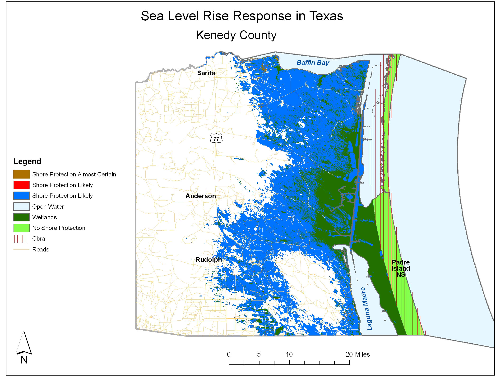
Kenedy County
Kenedy County (see map) has three small towns along US Highway 77, well inland of the land vulnerable to sea level rise: Rudolph, Armstrong and Sarita. Only 400 people or so live in the entire county.
As with Kleberg County, all of the county's Gulf Coast is within Padre Island National Seashore and hence will remain undeveloped.
Development is unlikely along the mainland as well. No growth is expected for the next 40-50 years, and the State Demographer in fact predicts a loss of about 50 people by 2040. The entire county is in holdings of either the King, Kenedy, or Armstrong ranches. None of the owners have evinced the slightest motion towards development, and our informants assure us no change is envisioned for the foreseeable future.
Windfarms are being considered for some of the Kenedy Ranch lands near the coast, but this is a very controversial project, with both of the other ranches fighting this project. Because windfarms consist of widely spaced pads for windmills, shore protection is nlikely even I they are built.
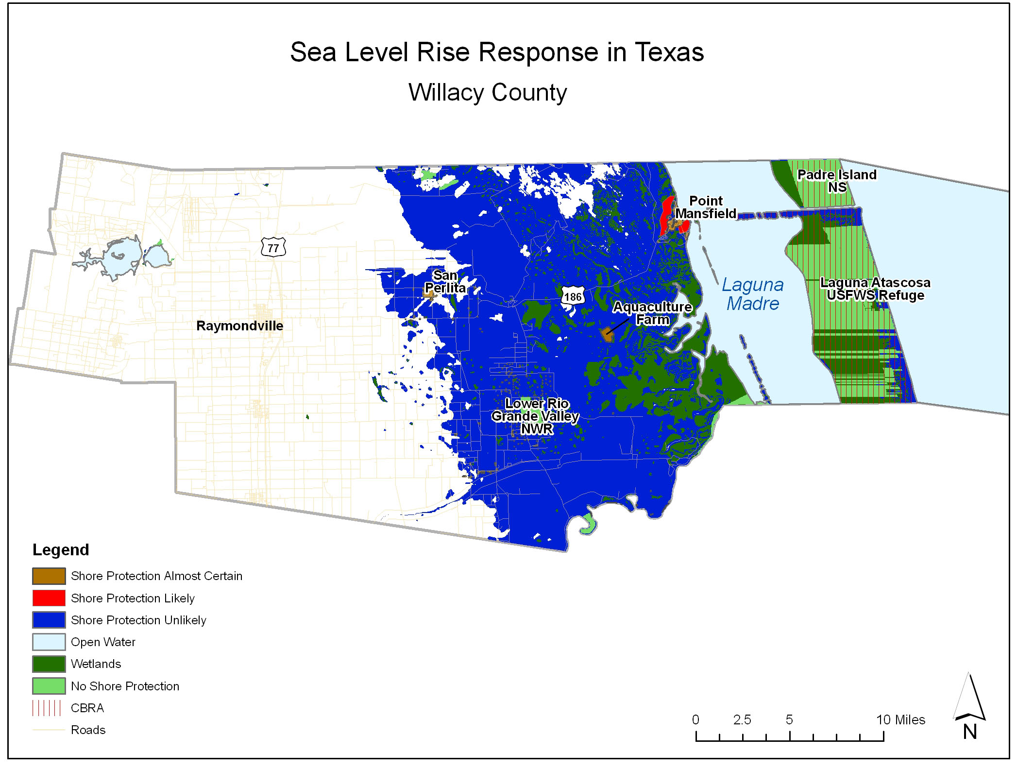
Willacy County
The coastal zone of Willacy County (see map) is undeveloped with the exception of Port Mansfield located in the northeast part of the county adjacent to Laguna Madre. Agricultural land, mixed forest and grasslands make the majority of the county. Padre Island has been artificially divided into two islands by a navigation channel connecting Port Mansfield with the Gulf of Mexico. North of that channel, the portion of North Padre Island in Willacy County is part of Padre Island National Seashore. South of the channel, about three quarters of South Padre Island within the county is part of the South Padre Island unit of Laguna Atascosa Wildlife Refuge. Private inholdings account for about 25% of this land, which could be developed and protected. Those lands are subject to the Coastal Barrier Resources Act, however, making a bridge from Port Mansfield extremely unlikely. Although the State of Texas has a right of way to build a road through much of South Padre Island, that right-of-way stops near the southern border of Willacy County. Access to the inholdings would thus be along the beach, making extensive development unlikely. The refuge is seeking to acquire those inholdings.
Along Laguna Madre, ittle growth is expected for Willacy County. Port Mansfield is expected to grow slightly. But growth is limited to the north of Port Mansfield by the King Ranch and to the south by a large complex of wetlands.
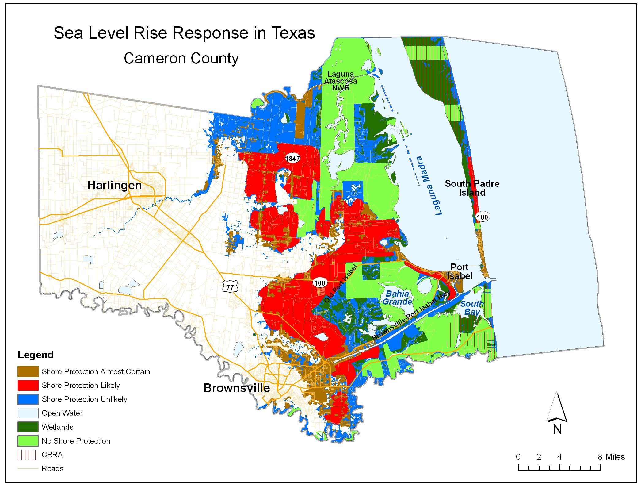
Cameron County
Unlike the three counties to its north, Cameron County (see map) has extensive development and continues to grow. Brownsville and Harlingen are the population centers, but the southern portion of South Padre Island is intensely developed with high-rises and large single-family homes. The developed portion of the barrier island will almost certainly be protected. Development is likely to continue at least another five miles north as utilities are extended. The northern half of South Padre Island within the county, however, is within the CBRA system and hence ineligible for federal subsidies. Development is possible, however, because the state of Texas has a right of way to extend State Park Road 100 to approximately the Willacy County Line. About a third of this land is within the South Padre Island unit of Laguna Atascosa Wildlife Refuge, however, which would preclude development of those portions of the shore. South of Padre Island, most of the land along the Gulf is part of Boca Chica State Park
Much of the Cameron County mainland fronting the Laguna Madre is sheltered from development by a vast complex of wetlands and protected areas. The Laguna Atascosa Wildlife Refuge encompasses more than half the shore north of Port Isabel.
Texas State Demographer projects Cameron County to be the 3rd fastest growing coastal county in Texas. Brownsville will be the center of this growth, and much of that growth will occur in lands less than 2- feet above sea level. The main axis of growth will extend north out of Brownsville, towards Arroyo City. Some development is also expected along the Brownsville Ship Channel, which would almost certainly be protected as sea level rises.
Governments Plan for Development of Most Land Vulnerable to Rising Sea (PDF, 7 pp., 1.3 MB, was originally published in Environmental Research Letters , Issue 3, Volume 4 (2009).