- New Report
- Regional set of maps
- All the Maps in Zipped File
- Single County Planning Maps
- Shore Protection Methods
- Data
Governments Plan for Development of Land Vulnerable to Rising Sea Level: Greater Houston, Texas
Excerpts from Report by Texas Sea Grant
Chambers County
Chambers County (see map) is lightly populated, mostly along Interstate 10 in the northern portion of the County near the cities of Mont Belvieu, Anahuac and Winnie. The Houston-Galveston Area Council population forecast maps showed only very diffuse growth in the county, with a small concentration on the east side of Anahuac. The Texas State Demographer expects a 167% increase in population by 2040 - equating to approximately 50 thousand new people, which is only about 1% of the increase of 4.8 million people expected in nearby Harris County.
The majority of its western and southern boundary draining into Galveston Bay. The Trinity River flows north-south to the Trinity River Delta near Lake Anahuac. Emergent and woody wetlands line the floodplains of this major river. Emergent herbaceous wetlands drape the southern border along East Bay, a sub-bay of Galveston Bay. The remaining part of the county to the north-west is predominately rice fields and other agriculture crops.
We think it prudent to project at least some waterfront development on the east side of Galveston Bay. There has been some talk in the past about some kind of high speed hydrofoil or similar craft traffic to Smith Point, so there is some possibility of development on the high ground in this area. We have also suggested some additional waterfront development on high ground on the waterfront to the north of Smith Point. These developments seem somewhat unlikely today, but given the relative proximity to Houston compared with the waterfront development occurring in Calhoun County, it would be unusual for these lands to remain overlooked by developers for the next 30-50 years.
Galveston County
Galveston County (see map) borders Galveston Bay to the east and south and includes all of Galveston Island and Bolivar Peninsula. The County is beginning to become densely populated. but significant areas of emergent wetlands still exist along areas bordering West Bay, south of FM 2004 and small patches of mixed evergreen and deciduous forest still exist in the mid west section of the County.
Major growth corridors are along I-45, State Hwy 96, and FM 646. Most of the current growth is occurring north of Dickinson Bayou, but many new developments are also planned for areas south of Dickinson Bayou. There are many areas east of I-45 shown as Protection Almost Certain that are not yet developed, but development is pretty much imminent in this area. Development seems likely east of I-45, but it is far enough in the future so that it is at least possible that development or shore protection might be avoided, so we have marked those areas as "protection likely."
The southern flank of mainland Galveston County is fringed by some fairly wide stretches of estuarine wetlands that will be relatively difficult to develop. The only existing development in this area is Harborwalk along West Bay.
Galveston Island is undergoing a development boom-both in high-rise condos and beach houses. We can be fairly certain that all areas not in wetlands and not otherwise protected will be developed. Therefore, we have labeled all of these areas as "protection almost certain" even though portions of the island are still undeveloped. The only areas where protection is not certain are Port of Galveston properties on Pelican Island and the far west end of Galveston Island. There is talk of port facilities sometime in the future for these properties, but there remains an outside change that some or all of those lands will eventually become part of a preserve.
The situation for Bolivar Peninsula is similar to that of Galveston Island. Any area not preserved will be developed. There are some significant areas already preserved-mainly the area on the west end of the Peninsula associated with the world-famous Bolivar Flats complex and some significant CBRA areas near High Island.
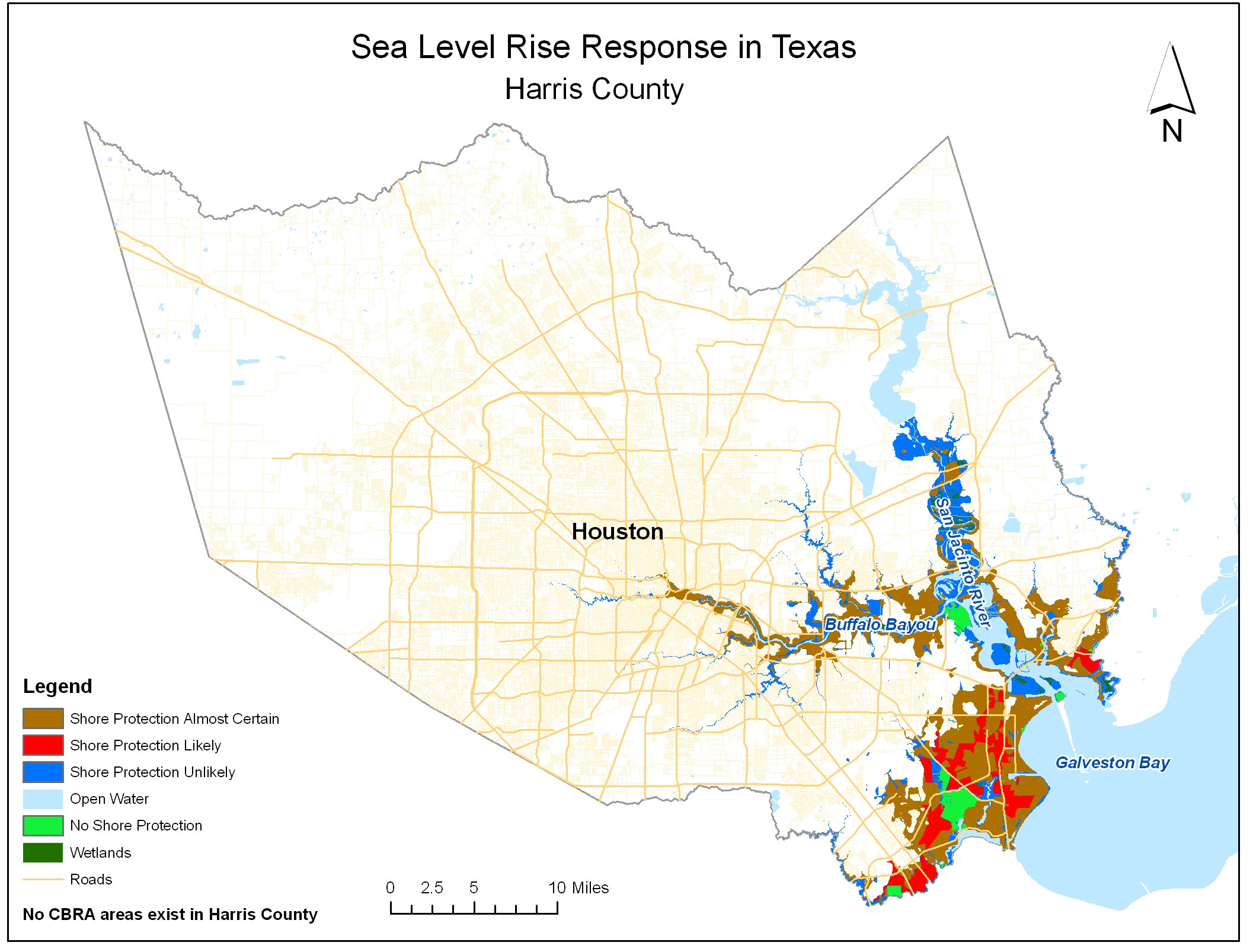
Harris County
Harris County is densely developed with some areas of pasture and grasslands to the northeast. Harris County does not directly border the Gulf of Mexico, but a small portion in the south-east corner reaches Galveston Bay with the San Jacinto River running north-south and Buffalo Bayou extending west-east in central section of the county. Some wetlands still exist in the northern floodplain of the San Jacinto River just south of Lake Houston.
Very little of Harris County (see map) in the 20-ft elevation zone is undeveloped. A few areas have yet to fill in, but there is little doubt that they will be developed given the projected population increase of 4.8 million people by 2040. Nevertheless, there are a few undeveloped areas in frequently-flooded floodplains where development is precluded by floodplain regulations, making shore protection unlikely.
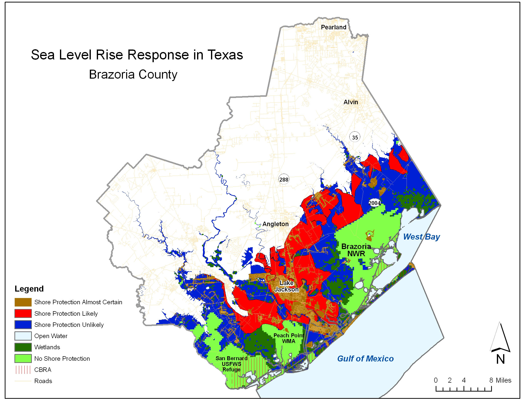
Brazoria County
Most development in Brazoria county (see map) centers mainly in and around the cities of Alvin and Pearland. A large section of southern Brazoria County is covered by emergent herbaceous wetlands. The remaining land uses include agricultural crops and mixed forest.
Brazoria County has a considerable amount of land tied up in state and federal reserves, and a good part of the coastline is sheltered by CBRA.
Brazoria County follows Harris County in terms of rate and amount of growth among the Texas Coastal counties. We forecast most of the growth to occur along the State Hwy 288 corridor centered in Lake Jackson and Angleton. Some growth could occur along the FM 2004 corridor coming into the Lake Jackson area from the west, but this growth is much less likely than along the 288 corridor. T he HGAC model showed growth in some portions of the eastern side of the county, which we sow as protection likely.
There is a large effort to preserve as much land as possible along West Galveston Bay, around Brazoria NWR. Little growth is expected in this area. Floodplains and large land holdings account make development and shore protection unlikely in much of the study area.
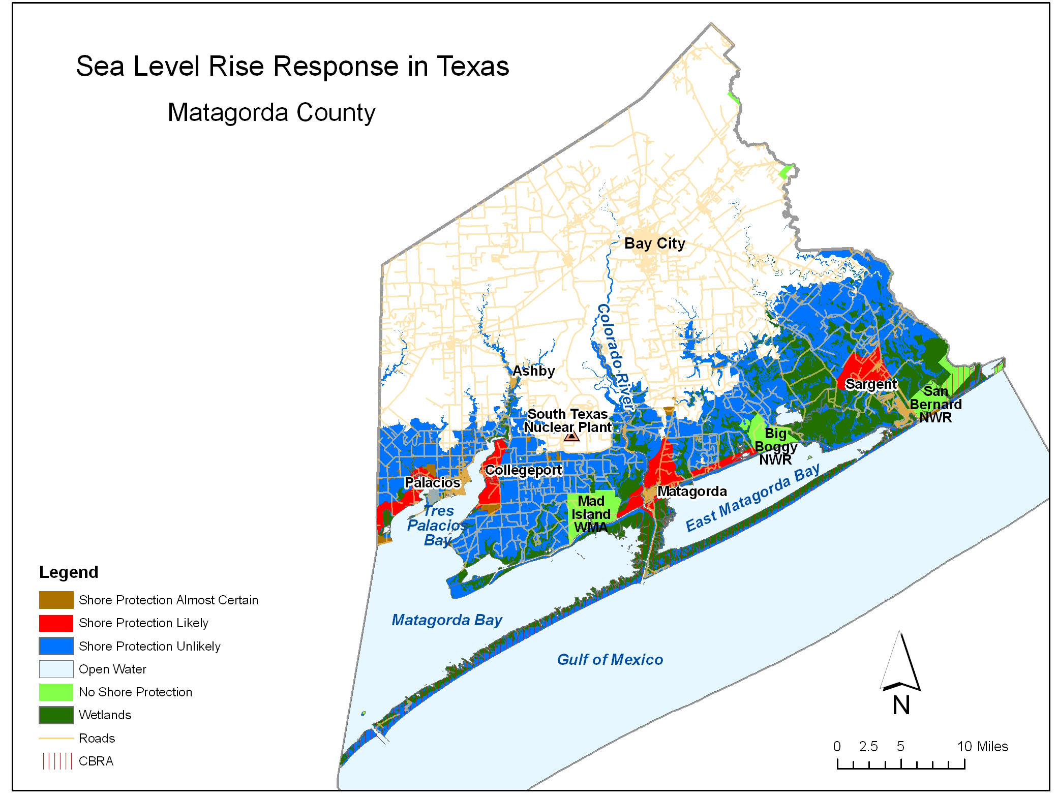
Matagorda County
Matagorda County (see map) is the southern most county in the Houston combined statistical area. The majority of the county's coastal area borders Matagorda Bay and East Matagorda Bay.
Matagorda Peninsula, a barrier spit, accounts for almost all of the county's shoreline along the Gulf of Mexico. Matagorda County has the most extensive CBRA coverage of any county along the Texas coast, a fact that does not sit well with our informants in the real estate industry. Only a small fraction of Matagorda Peninsula just east of the Colorado River outlet has any development on it. No development is forecast for any other part of the barrier island complex off of Matagorda County.
Several midsized conservation lands exist along the Bay and Gulf of Mexico coast. Mad Island Wildlife Management Area is on the mainland side of Matagorda Bay just west of the City of Matagorda. The Big Boggy National Wildlife Refuge is on the north, mainland side of East Matagorda Bay. The San Bernard National Wildlife Refuge is adjacent to the Gulf of Mexico in northern Matagorda County. Emergent wetlands exist along the shoreline of Matagorda Bay and the north section of the County adjacent to the Gulf of Mexico.
Nevertheless, development is expected along much of the bay shores. Palacios on the west end of the county is just beginning to experience some growth. It is likely that the waterfront areas to the west of Palacios will be developed in the coming decades.
A new nuclear plant is planned near the existing South Texas Nuclear Plant (STNP). Collegeport will likely experience significant growth as a result of this new venture. We expect the area from Collegeport north along Tres Palacios Bay to the head of the bay to be developed. The area south of Collegeport to the Bay and east to Mad Island Reserve is owned by a single landowner with no interest in selling or developing, and hence we view that area as unlikely to be developed or protected.
Other areas where development is expected include Matagorda, the waterfront along the ICWW between the Mad Island Preserve and the Big Boggy preserve, and the areas to the west of Sargent.
Governments Plan for Development of Most Land Vulnerable to Rising Sea (PDF, 7 pp., 1.3 MB, was originally published in Environmental Research Letters , Issue 3, Volume 4 (2009).