- New Report
- Regional set of maps
- All the Maps in Zipped File
- Single County Planning Maps
- Shore Protection Methods
- Data
Governments Plan for Development of Land Vulnerable to Rising Sea Level: Golden Triangle, Texas
Excerpts from Report by Texas Sea Grant
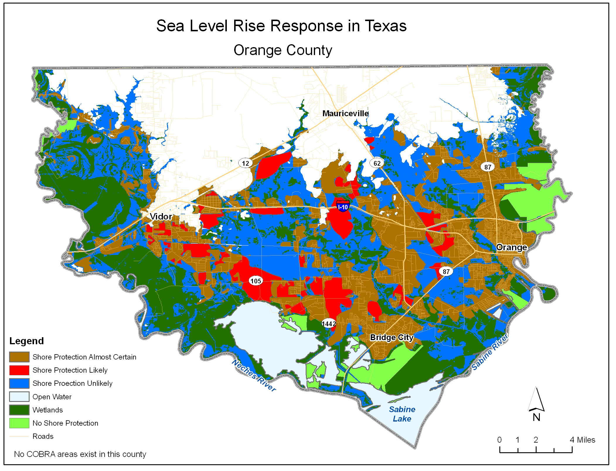
Orange County
Although Orange county (see map) is not adjacent to the Gulf of Mexico, about three-fourths of the county is below 20 feet in elevation and within the project study area. The southern portion of the county is nestled between Sabine Lake and the Sabine River to the south and east and the Neches River to the west, creating a "V" shape appearance.
Large patches of emergent herbaceous and forested wetlands line the Sabine and Neches Rivers floodplains. Development is constrained in these areas because of frequent and long-term flooding in these river bottoms.
Small patches of low and high intensity development are located near Bridge City in the south, Vidor to the west, and the city of Orange to the east. Amongst the development in the southern "bowl" of the county, small areas of pastures, grasslands and mixed forest remain.
Our informants predict that most of the future growth will be along FM 1442 and FM 105 near Bridge City, as well as in and around Vidor, as Beaumont, in eastern Jefferson County, expands due to projected construction of industrial complexes. The corridors connecting Vidor to Bridge City and Mauriceville are also expected to experience significant growth. Additional growth is also expected along Interstate 10 which straddles the midsection of the county
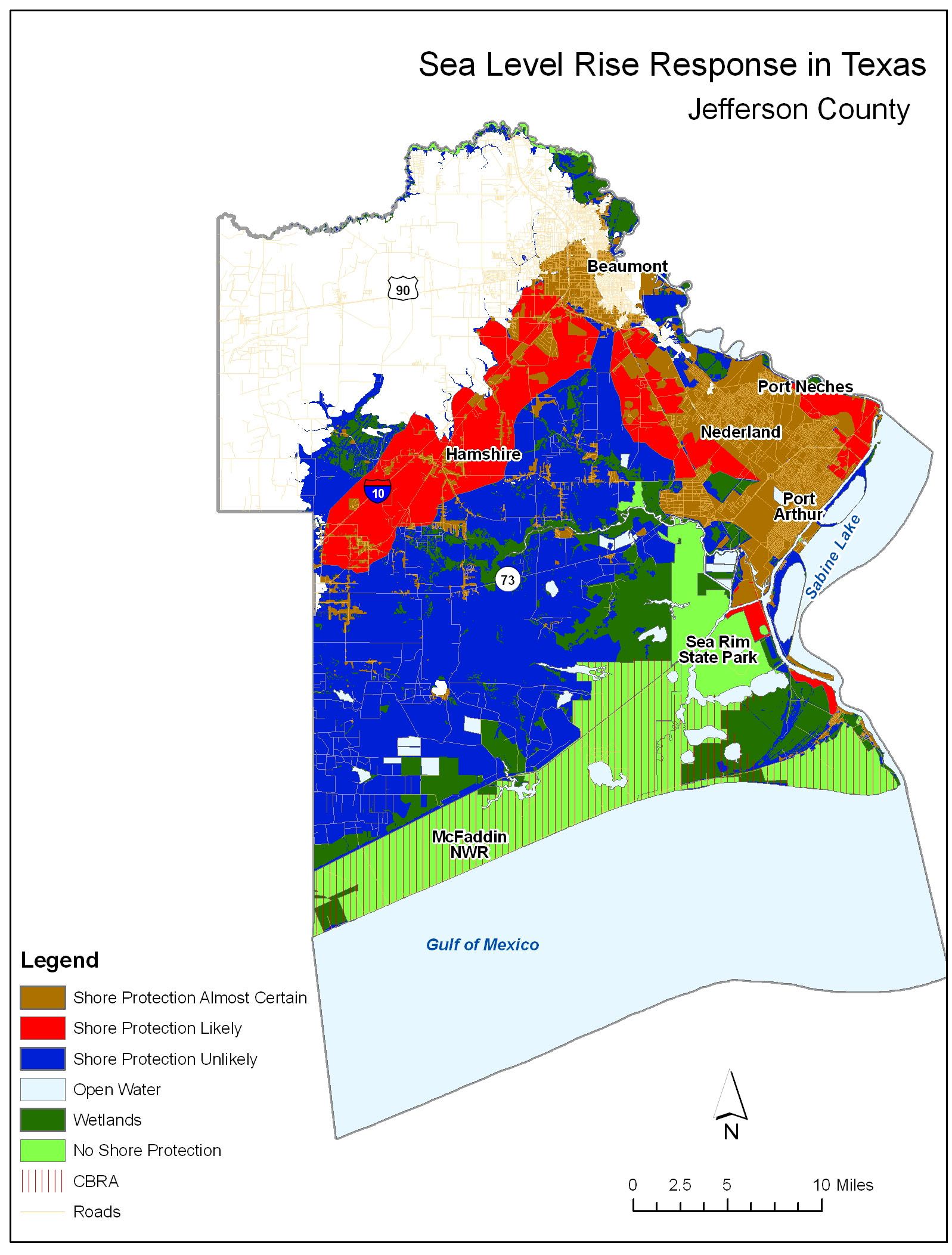
Jefferson County
Jefferson County (see map) borders Louisiana to the east and Chambers County to the west. This county is predominately pasture and agricultural land. Much of the coastal areas are made up of emergent herbaceous wetlands. However, dense development exists along the eastern border of the county in and around Beaumont, Nederland, Port Neches and Port Arthur, the famous "Golden Triangle" of Texas.
Beaumont's major growth direction will be to the west along Hwy 90 and to the north, for the most part inland of the areas vulnerable to sea level rise.
Significant growth may occur to the southwest along I-10. New subdivisions are spouting up in Hamshire towards Winnie. It is not clear how dense this new development will be, but there will likely be some kind of development in this corridor, even if dispersed. Those lands are likely to be protected as sea level rises. Less growth is currently expected to the east of the I-10 corridor toward Port Neches, although some expansion of Port Neches back to the west and some infill to the east are likely/
The main driver of new growth in this county will be new activity associated with the refinery industry. Shell will invest at least $7 billion in new refinery capacity in Port Arthur, and several other refineries are gearing up for major expansion. Development is precluded along the the southern flank of Jefferson County by state and federal preserves and CBRA designation. Little growth is expected between State Hwy 73 and the preserves.
Governments Plan for Development of Most Land Vulnerable to Rising Sea (PDF, 7 pp., 1.3 MB, was originally published in Environmental Research Letters , Issue 3, Volume 4 (2009).