- New Report
- Regional set of maps
- VA maps in zipped file
- Single County Planning Maps
- Shore Protection Methods
- Data
Governments Plan for Development of Land Vulnerable to Rising Sea Level: Hampton Roads, Virginia
From EPA report prepared by Virginia Institute for Marine Sciences (PDF 8.7 MB) and other experts
Background
Hampton Roads is the southernmost coastal planning district in Virginia. Extending from the North Carolina border to the York River, the region has 16 localities whose combined population is more than 1.5 million. Lands vulnerable to sea level rise include beaches along the Atlantic Ocean and Chesapeake Bay, both sides of the lower James River, a barrier spit and back barrier bays near North Carolina's Outer Banks, and parts of the York River.
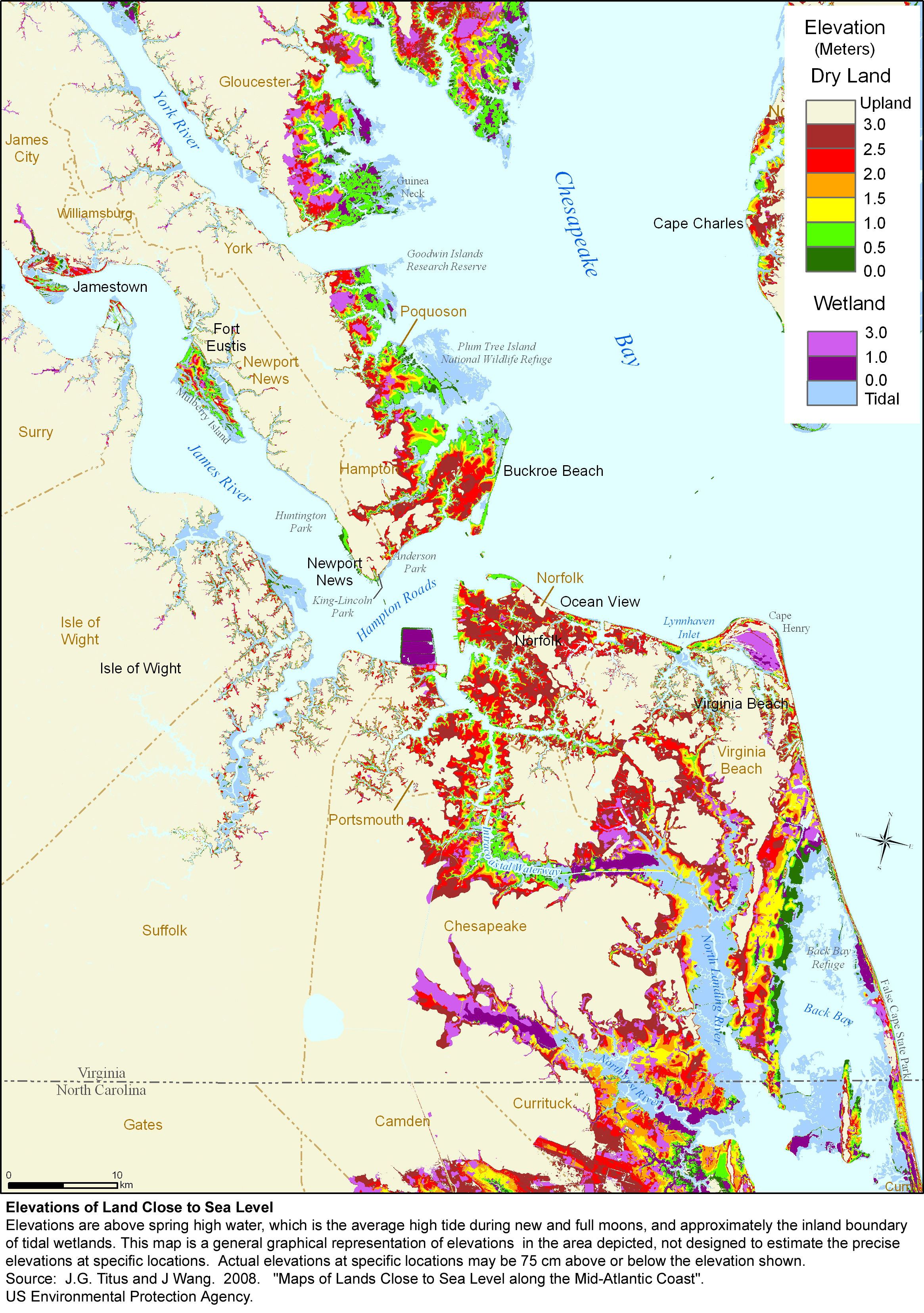
Elevations
Table 1 and our elevation map show that most of the vulnerable dry land in the Hampton Roads area is located within Virginia Beach or Chesapeake. These low areas are not, however, in the urban portions of those jurisdictions. Most of Virginia Beach's very low land is either along the back-barrier bays near the North Carolina border, or along the North Landing River. The lightly developed southern half of this city is mostly within 3 meters above mean spring high water. Most of Chesapeake's low land is around the Northwest River near the North Carolina border, or the along the Intracoastal Waterway. Hampton and Newport News have substantial areas between the 1.5- and 3-meter contours, with a few areas within 1 meter above the tides.
The town of Poquoson is extensively developed and probably the community that is most vulnerable to rising water levels. Although the city's corporate limits include some high ground, the town is approximately 50% wetland and almost all residential lands are at least 3 meters above the tides; several neighborhoods are vulnerable to even minor surges in Chesapeake Bay. The localities located farther up the James and York rivers have less low land. An important exception is historic Jamestown Island, which has been gradually submerged by the rising tides since the colony was established 400 years ago. Some researchers believe that sea level rise was one of the reasons that the capital was moved to Williamsburg instead of being rebuilt when fire destroyed the original building in 1699.
Vulnerable Habitat
Sandy beaches with dune systems comprise the Chesapeake Bay shoreline of the City of Virginia Beach and Norfolk, from Cape Henry to the mouth of the James River. Overall trends in the last century show the dunes east of the Lynnhaven inlet advancing into the Bay. West from the inlet, erosion, beach nourishment, and fill operations as well as condominium development and shoreline armoring have affected the accretion and erosion patterns. Along the shores of Norfolk, the rate of erosion is generally low, and beach accretion occurs along much of the shore. Most of the shore along Chesapeake Bay is protected by groins and breakwaters, and hence relatively stable. On the other side of the James River, the Bay shoreline is dominated by marshes, many of which are eroding.
Along the bay shores of the Hampton Roads planning district, current sea level trends or a modest acceleration are unlikely to substantially diminish beach habitat, compared to the existing impact from human activities. Urbanization and foot traffic impair beach habitat compared with a pristine environment. Nevertheless, the commitment to maintain the existing beaches make further habitat degradation unlikely because the beaches will continue to exist, unless sea level rise accelerates enough to cause officials to rethink that commitment.
Other tidal habitat is more vulnerable. Approximately one quarter of the tidal wetlands in the area are within Poquoson's Plum Tree Island National Wildlife Refuge. Unlike most mid-Atlantic wetlands, these wetlands appear to be unable to keep pace with the current rate of sea level rise. This refuge has very limited human access because unexploded ordnance remains on the island from its prior use as a bombing range. The refuge has substantial forested dune hummocks (CPCP, 1999), and a variety of mammals use the higher ground of the refuge. Endangered sea turtles, primarily the loggerhead, use the near shore waters. Oyster, clams, and blue crabs inhabit the shallow waters and mudflats, and striped bass, mullet, spot, and white perch have been found in the near shore waters and marsh.
The wetlands in York County appear able to keep pace with the current rate of sea-level rise. Assuming that they are typical of most wetlands on the western side of Chesapeake Bay, they would become marginal with a modest acceleration and be lost if sea-level rise accelerates to 1 cm per year (Reed et al., 2008). Bald eagles currently nest in the Goodwin Islands National Estuarine Research Reserve (Watts and Markham, 2003). This reserve includes intertidal flats, 100 ha (300 ac) of eelgrass and widgeon grass (VIMS, date unknown), and salt marshes dominated by salt marsh cordgrass and salt meadow hay. Even if the wetlands keep pace with rising sea level, the habitat just above the wetlands could be lost as it converts to marsh. This habitat includes forested wetland ridges, dominated by estuarine scrub/shrub vegetation, and ridges with oak and pine black gum (Nyssa sylvatica), and cottonwood (Populus deltoides).
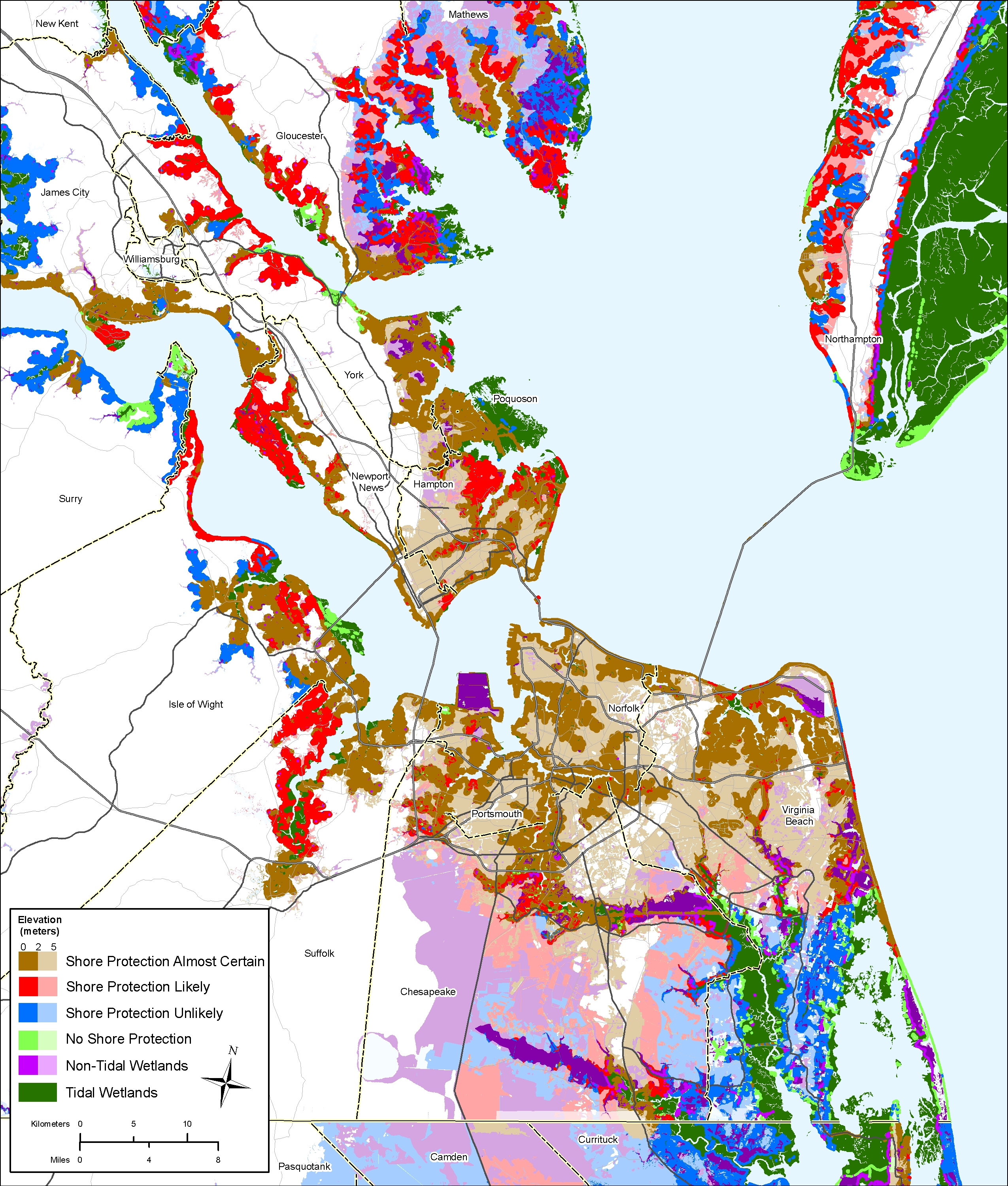
Likelihood of Shore Protection
Our summary map and Table 2 show the likelihood of shore protection for the Hampton Roads planning district. Within the urbanized areas (Norfolk, Portsmouth, Hampton, Newport News, and parts of Virginia Beach and Chesapeake) planners expect that residential, commercial, and other developed lands are very likely to be protected. High densities, central water and sewer, and existing shoreline armoring and beach nourishment are all consistent with that expectation. The only significant exception is a small amount of floodprone land in Newport News near the border with Hampton, where the city expects to purchase homes and add the land to an adjacent waterfront park.
Virginia Beach has sandy shores along both the Atlantic Ocean and the mouth of Chesapeake Bay. Dunes dominate the bay shore, but much of the developed ocean shore is protected by a seawall, and periodic beach nourishment has occurred since the mid-1950s. Given current policies, regional planners view the northern two-thirds of Virginia Beach's ocean shore as likely or very likely to be protected. As the state's only ocean resort, this city has a combination of high-rise condominiums and hotels, low-rise motels, restaurants and shops, and single-family homes with high property values. The southern third of the ocean coast is within a state park or Back Bay National Wildlife Refuge, which makes shore protection very unlikely.
Along Chesapeake Bay, by contrast, the Virginia Beach shore has substantial dunes, with homes set well back from the shore in some areas. Although the ground is relatively high, beach nourishment has been required on the bay beaches at Ocean Park. Norfolk has maintained its beaches along Chesapeake Bay mostly with breakwaters and groins. Shores along other bodies of water are being armored. Of Norfolk's 167 miles of shoreline, 70 miles have been hardened.
Outside of the urban core, however, much of the land is less likely to be developed and protected. Since 1979, Virginia Beach has had a "Green Line" south of which the city tries to maintain the rural agricultural way of life. Because development has continued, Virginia Beach has also established a "Rural Area Line," which coincides with the Green Line in the eastern part of the city and runs 3 miles south of it in the western portion. Below the Rural Area Line, the city strongly discourages development and encourages rural legacy and conservation easements. City officials asked EPA to assume that shore protection is unlikely south of the Rural Area Line - even lands that are now developed. In effect, the city's land use plan to preserve rural areas will serve to preserve the coastal environment as sea level rises throughout the coming century and beyond. To the west, by contrast, the City of Chesapeake is encouraging development in the rural areas, particularly along major corridors. Therefore, shore protection is likely in a greater portion of Chesapeake than Virginia Beach. Comprehensive plans in the more rural counties such as Isle of Wight and James City tend to focus less on preserving open space and more on encouraging growth in designated areas. Therefore, areas shown as "shore protection unlikely" reflect the fact that development is still decades away, rather than a conscious decision to preserve open space. Table 2 quantifies the area of land within 1 meter above the tides by likelihood of shore protection.
Governments Plan for Development of Most Land Vulnerable to Rising Sea (PDF, 7 pp., 1.3 MB, was originally published in Environmental Research Letters , Issue 3, Volume 4 (2009).