- New Report
- Regional set of maps
- VA maps in zipped file
- Single County Planning Maps
- Shore Protection Methods
- Data
Governments Plan for Development of Land Vulnerable to Rising Sea Level: Northern Neck, Virginia
From EPA report prepared by Virginia Institute for Marine Sciences (PDF 8.7 MB) and other experts
Background
Comprising the land between the Rappahannock and Potomac rivers, the Northern Neck planning district is primarily rural, with approximately one-third of the land area currently farm land. Major developed areas lie along the shores of Chesapeake Bay and the Potomac River, while the Rappahannock River banks remain largely undeveloped, especially upstream from Lancaster County.
Elevations
For the most part, the Northern Neck has rolling hills with relatively few low spots. Many coastal homes are along bluffs some of which are eroding. The available topographic data (see Table 1 and the elevation map) suggest that within the Northern Neck planning district, Lancaster County has the most dry land located below 2 meters (between 14 and 28 square kilometers).
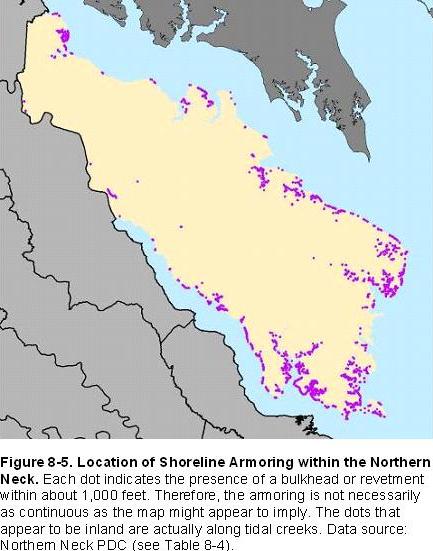
The lowest lying community in this region is Lewisetta in Northumberland County. Lewisetta is unique in that it is the only community along the Potomac River vulnerable to tidal inundation in the next century. Water in some ditches there already rises and falls with the tides, and some areas drain through tide gates. With a fairly modest rise in sea level, wetlands may begin to take over portions of people's yards, the tide gates will close more often, and flooding will be more frequent. Elsewhere in this region, the primary impact of sea level rise is the gradual erosion of land that, for the most part, is high enough to avoid flooding during even the most severe storms. Homes are often set back from the shore a few hundred feet, with land at least 5 feet above the tides. Nevertheless, shore erosion control structures are often built to protect back yards from shore erosion. Shoreline armoring is very commonplace in this region (see map) and offered in billboards along major highways.
Lancaster County and Richmond County
The Lancaster County planning documents show that almost all the county's shoreline along the Rappahannock River and Fleets Bay already has some sort of armoring in place. Given the relatively high ground along these shores, the County generally expects that these areas are almost certain to be protected in the future. Areas without armoring, however, include North Point, Bluff Point, and some shorelines along the tributaries. Nevertheless, most of these areas will be developed as retirees and others who desire pleasant waterfront homes move into the county. See summary map
Upstream along the Rappahannock River, district planners view currently unprotected boat landings, marinas, and coastal residential development (generally 5-acre zoning) along the river and adjacent creeks in southern Richmond County as likely to be protected. Farther up the river, however, they view development-and hence shore protection-as unlikely because the marshy shores make for less attractive development opportunities.
Northumberland County
Along Chesapeake Bay in Northumberland County, the Northern and Southern necks are fairly densely developed. The County believes the low-lying areas on the neck north of the Great Wicomico River, including the town of Reedville, are almost certain to be protected, even if sea level rises several feet. If the fast ferry service from Crisfield, Maryland, to Virginia is approved, the ferry terminal in Virginia would probably be at the end of US-360 in Reedville, which would further increase development and the likelihood of protection. Therefore, Reedville is shown as almost certain to be protected. The district planners expect the undeveloped coastal areas in the center of the county's bayshore to be developed, given the potential for tourism and seasonal homes. As a result, the maps identify them as likely to be protected-and certain where coastal structures already exist.
Along the Potomac River, land values are higher than along the Rappahannock River. Some coastal developments, however, such as Lewisetta, are much more low-lying. The risk of tidal flooding could lead to an increased cost of protection for those areas where it will be necessary either to elevate land and structures or to encircle communities with dikes and tide gates. Because Lewisetta will require protection from inundation as well as erosion, the maps delineate this town as likely rather than almost certain to be protected. The areas from Lewisetta southeast to Vir-Mar Beach are all developed or will be developed, and are also likely to be protected.
The planning staff also noted that the cost of above-ground "mounded" septic systems has decreased, thereby reducing an impediment barrier to development in the relatively low-lying areas on Cherry Point Neck north and west of Lewisetta. With development already taking place on Cherry Point Neck (and some coastal armoring structures already in place) the maps assume that Cherry Point Neck is certain to be protected.
Westmoreland County
Westmoreland County has numerous substantial developments along the Potomac River, most important of which is the historic town of Colonial Beach. At the turn of the century, Colonial Beach was a beach resort destination for Washingtonians, who would generally arrive by steamboat. The community had a large boardwalk, many hotels, a skating rink, and a large beach. The gradual decline of river and bay beach resorts during the latter half of the 20th century eliminated most tourism, but the community is still the most important tourist destination in the county. The beach there is still an important recreational center for both tourists and area residents. Much of that beach has been eliminated by shoreline armoring, but the state of Virginia has taken an interest in maintaining the beach that remains. Colonial Beach will almost certainly be protected for the foreseeable future.
To the southeast of Colonial Beach lie a number of undeveloped bluffs and conservation areas, including a state park and George Washington's birthplace. Some of these areas probably will not be protected, although Washington's birthplace is certain to be protected. The homes along the bluffs west of Stratford Hall will soon require shore protection. In the Glebe area, townhouses and other residences are being built, which means that this entire area is almost certain to be protected, according to the PDC. On the other land, the development proposed for Coles Neck is likely, but not certain.
The considerations for Cherry Point in Northumberland County also apply to Sandy Point Neck, but development there is not quite as imminent as Cherry Point. As a result, the planning staff views this area as likely to be protected.
The stakeholder review identified a number of errors in the draft maps. Most important, because Colonial Beach is extending sewer service the area between Colonial Beach and Potomac Beach this land is certain to be protected. Much of the land between Monroe Bay and VA-205 is still lightly developed, but again, because sewer service is coming to that area, it is certain to be developed and protected from rising sea level.
Coles Neck, a secondary growth area, is also getting sewer service. The planners suggested that the areas previously depicted as red should be changed to brown, with blue changed to red. Jackson Creek and the Potomac River is the approximate eastern boundary of this projected growth area, and Lower Machodoc Creek is the western boundary
Governments Plan for Development of Most Land Vulnerable to Rising Sea (PDF, 7 pp., 1.3 MB, was originally published in Environmental Research Letters , Issue 3, Volume 4 (2009).