- New Report
- Regional set of maps
- VA maps in zipped file
- Single County Planning Maps
- Shore Protection Methods
- Data
Governments Plan for Development of Land Vulnerable to Rising Sea Level: The Potomac River
From EPA report prepared by Virginia Institute for Marine Sciences (PDF 8.7 MB) and other experts
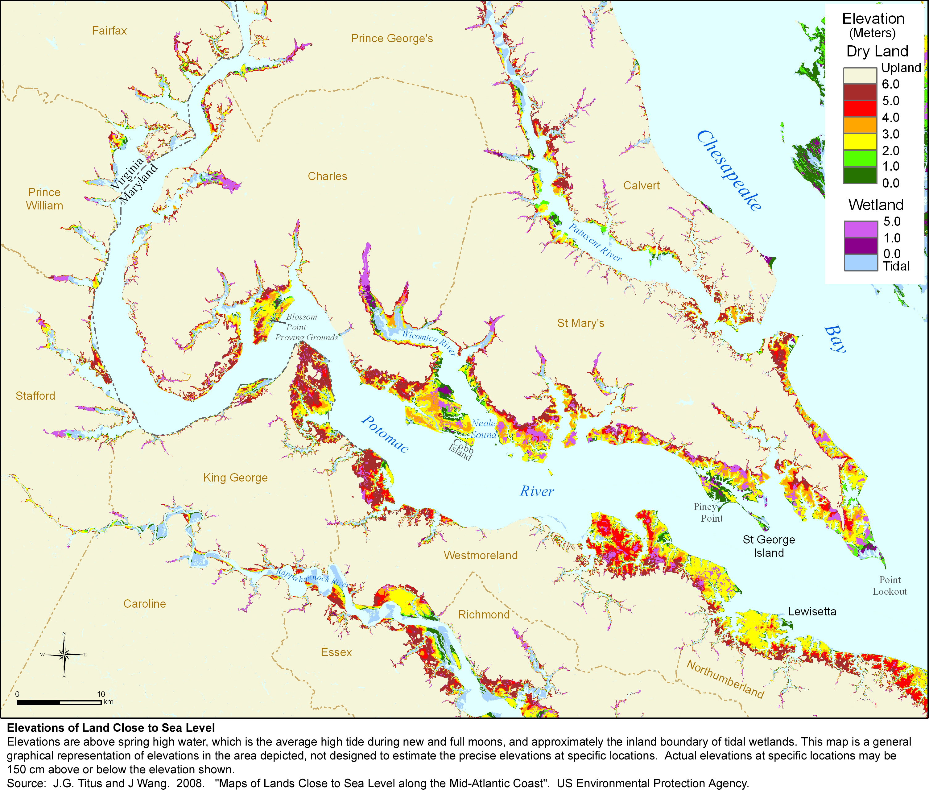
Elevations
The available topographic data do not allow a meaningful estimate of the land within 1 meter above the tides; but it does suggest that the counties along the Potomac River have between 24 and 53 square kilometers of dry land (and between 4 and 8 square kilometers of nontidal wetlands) below 2 meters (Table 1). Although Westmoreland and King George County have the greatest amount of low land (a combined area of between 14 and 33 square kilometers below 2 meters), the low areas are well distributed, as shown in the elevation map Many coastal homes are along bluffs, some of which are eroding.
The most low-lying community on the Virginia side of the Potomac River is Lewisetta in Northumberland County. Lewisetta appears to be the only community along the Potomac River vulnerable to tidal inundation with a 50-100 cm rise in sea level. Water in some ditches rises and falls with the tides, and some areas drain through tide gates. With a fairly modest rise in sea level, wetlands may begin to take over portions of people's yards, the tide gates will close more often, and flooding will be more frequent. Somewhat higher, Old Town Alexandria and Belle Haven (Fairfax County) both flood occasionally from high levels in the Potomac River. But outside a small number of communities, shore erosion-not inundation-will almost certainly be the primary factor forcing people to choose between shore protection and land loss.
Shore Protection
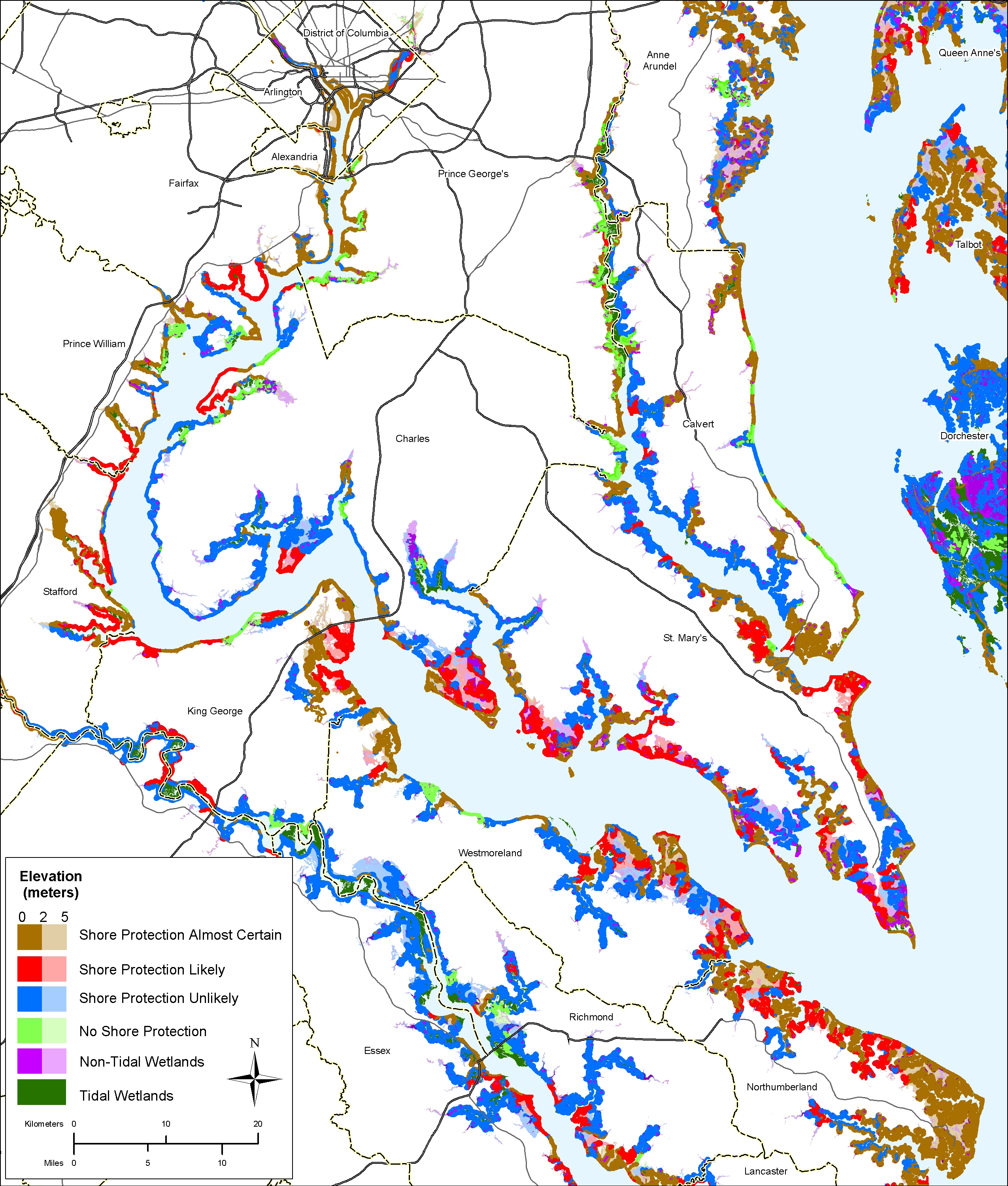
West of Chesapeake Bay, the southwestern shoreline of the Potomac River is the border between Maryland and Virginia. As a result, islands in the Potomac River, no matter how close they are to the Virginia side of the river, are part of Maryland or the District of Columbia. Moreover, most efforts to control erosion along the Virginia shore take place partly in Maryland (or DC) and thus could potentially be subject to Maryland (or DC) policies.
Given the relatively high ground of most land along the Potomac, planners from both Maryland and Virginia are almost certain that medium and high-density development will be protected, accounting for about two thirds of the Potomac shoreline (see Map F.12 and Table F.8).
The other third of the shoreline is unlikely to be protected because of governmental policies in Maryland, and a combination of government policies and economics in Virginia. Shore protection is unlikely along most shores in Charles County (Maryland) because they are in the resource conservation area defined by the state's Critical Areas Act (and hence limited to one home per 20 acres). A significant portion of Prince George's County's 58 km of shoreline along the Potomac and its tributaries are owned by the National Park Service and other conservation entities that preclude shore protection.
In Virginia, parks also account for a significant portion of the shore. In King George County, several developers created subdivisions with lot sizes greater than 10 acres to avoid the County's septic regulations. Other developers have set development back from low-lying marsh areas to avoid problems associated with flooding and poor drainage. In Stafford County, the CSX railroad line follows the river for several miles, and is set back to allow shores to erode, but not so far back as to make development likely between the railroad and the shore.
Vulnerable Habitat
The Lower Potomac River includes a diverse mix of land uses and habitat types. Freshwater tidal marshes in the Lower Potomac are found in the upper reaches of tidal tributaries. In general, freshwater tidal marshes in the Lower Potomac are keeping pace with sea-level rise through sediment and peat accumulation, and are expected to continue to do so, even under higher sea-level rise scenarios (Reed et al., 2008).
Brackish tidal marshes are a major feature of the downstream portions of the region's rivers. In general, these marshes are keeping pace with sea-level rise today, but are considered marginal under moderate sea-level rise rate increases and are likely to be lost if sea level accelerates (Reed et al., 2008). Loss of brackish tidal marshes would eliminate nesting, foraging, roosting, and stopover areas for migrating birds. Significant concentrations of migrating waterfowl forage and overwinter in these marshes in fall and winter. Rails, coots, and migrant shorebirds are transient species that feed on fish and invertebrates in and around the marshes and tidal creeks. The rich food resources of the tidal marshes also support rare bird species such as bald eagle and northern harrier (White, 1989).
Unnourished beaches and tidal flats of the Lower Potomac are likely to erode as sea levels rise. Impacts on beaches are highly dependent on the nature of shoreline protection measures selected for a specific area. For example, at the mouth of the Wicomico River in Maryland are the developed areas of Wicomico Beach and Cobb Island. Assuming that the shores of Cobb Island continue to be protected, sea-level rise is likely to eliminate most of the island's remaining beaches and tidal flats.
Finally, where the cliffs and bluffs along the Lower Potomac are not protected (e.g., Westmoreland State Park, Caledon Natural Area), natural erosional processes will generally continue, helping to maintain the beaches below.
Above Indian Head, the Potomac River is fresh. Tidal wetlands are generally expected to keep pace with rising sea level in these areas (see Chapter 3). Nevertheless, the Dyke Marsh Preserve faces an uncertain future. Its freshwater tidal marsh and adjacent mud flats are one of the last major remnants of the freshwater tidal marshes of the Upper Potomac River (Johnston, 2000). A recent survey found 62 species of fish, nine species of amphibians, seven species of turtles, two species of lizards, three species of snakes, 34 species of mammals, and 76 species of birds in Dyke Marsh (Engelhardt et al., 2005). Many of the fish species present (e.g., striped bass, American shad, yellow perch, blueback herring) are important for commercial and recreational fisheries in the area (Mangold et al., 2004).
Parklands on the Mason Neck Peninsula will be managed for conservation, but shoreline protection on adjacent lands may result in marsh loss and reduced abundance of key bird species. The Mason Neck National Wildlife Refuge hosts seven nesting bald eagle pairs and up to 100 bald eagles during winter, has one of the largest great blue heron colonies in Virginia, provides nesting areas for hawks and waterfowl, and is a stopover for migratory birds.
Governments Plan for Development of Most Land Vulnerable to Rising Sea (PDF, 7 pp., 1.3 MB, was originally published in Environmental Research Letters , Issue 3, Volume 4 (2009).