- New Report
- Regional set of maps
- VA maps in zipped file
- Single County Planning Maps
- Shore Protection Methods
- Data
Governments Plan for Development of Land Vulnerable to Rising Sea Level: The Delmarva Peninsula
From EPA report prepared by Virginia Institute for Marine Sciences (PDF 8.7 MB) and other experts
Along the Atlantic Ocean between the mouths of the Chesapeake and Delaware bays lie approximately 200 kilometers of ocean beaches-mostly barrier islands--and only 30 kilometers have been developed. But the oceanfront development includes major resorts such as Ocean City (MD), Rehoboth (DE) and Dewey Beach (DE). The mainland behind those barrier islands is starting to become developed, especially in Delaware and Maryland. This page summarizes the potential vulnerability and likely responses to sea level rise along the Atlantic coast of the DelMarVa peninsula for all three states. For additional details about the likelihood of Shore protection along both the Atlantic and Chesapeake sides of the Virginia Eastern Shore, please see the pages on Accomack and Northampton counties.
Coastal Elevations and Risk of Inundation
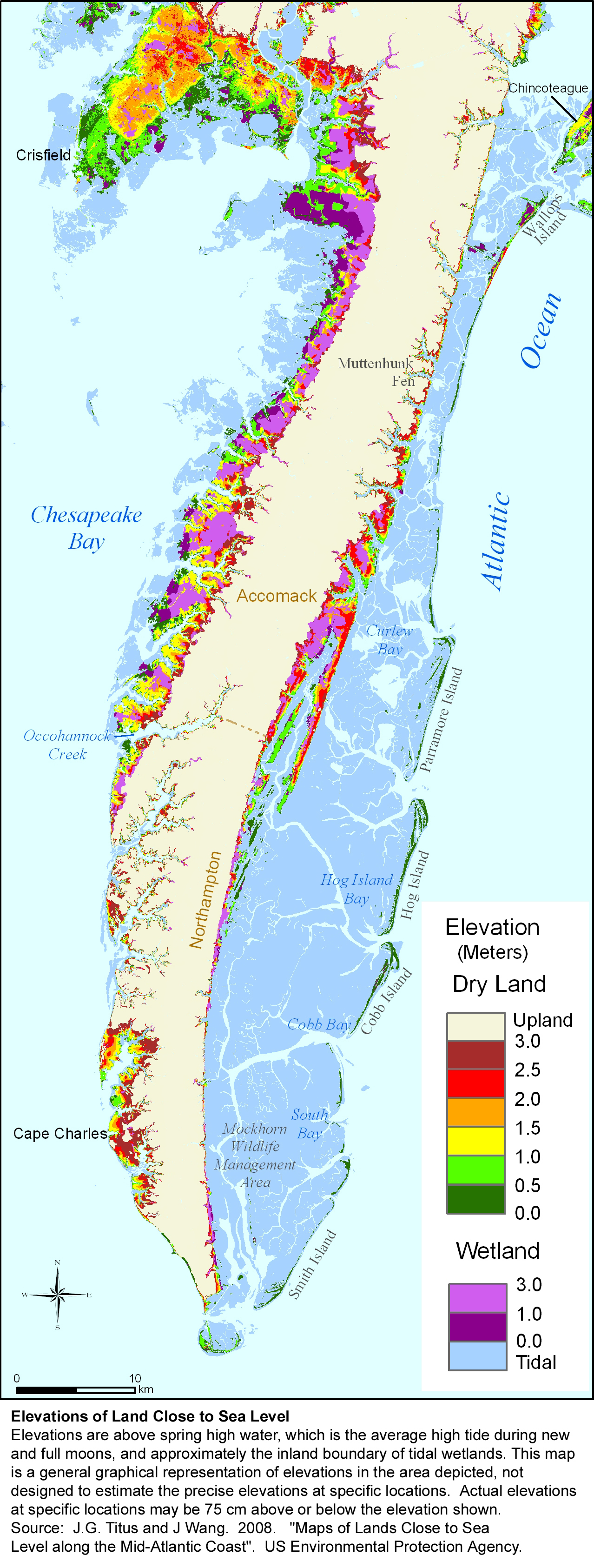
Maps 1 and 2 show the elevations of lands close to sea level along the Atlantic Coast of the DelMarVa peninsula. Most noticeable is the 764 square kilometers of tidal wetlands behind Virginia's undeveloped barrier islands, of which 375 square kilometers are mudflats, giving this area the largest concentration of mudflats in the Mid-Atlantic. The peninsula also has about 90-180 square kilometers of dry land and nontidal wetlands within 1 meter above spring high water (see Table 1).
The greatest concentrations of dry land within a few meters above spring high water appear to be along a few necks between the southern border of Accomack County and Wachapreague (opposite Cedar and Parramore islands), Chincoteague Island, and the mainland between Chincoteague Bay and Indian River Bay (opposite Bethany and Ocean City). The barrier islands are a small portion of the low land.
Most of Virginia's lands close to sea level are in the Eastern Shore counties of Accomack and Northampton. These two counties contain 70 percent of the state's tidal wetlands. Accomack also contains 18 percent of the dry land within 2 feet above the tides, as well as three developed islands that are potentially vulnerable: Tangier, Saxis, and Chincoteague.
The rural Eastern Shore of Virginia is approximately 70 miles long and 5 to 10 miles wide, with the Atlantic Ocean to the east and Chesapeake Bay to the west. These shorelines provide a wealth of recreational and tourist opportunities for residents and visitors alike. A number of small towns and villages lie along the shoreline, but the majority of the land area is either undeveloped or used for agricultural purposes. The population of the region grew modestly from approximately 45,000 in 1990 to 51,000 in 2000. Development pressures are not heavy yet.
The need to cross the 17-mile Chesapeake Bay Bridge-Tunnel to reach the Hampton Roads area has made commuting impractical for most people, given the $20 round trip toll and the occasional severe traffic jams when an accident occurs. Recently, however, the bridge portion was expanded to two lanes in each direction, and the one-day roundtrip toll was reduced to $14. As a result, many observers expect development to increase soon in the southern portion of the county, especially along the bayside. Some people commute from northern Accomack County to Salisbury and other towns in southern Maryland, and Chincoteague is a popular resort and gateway to Assateague Island National Seashore. This county seems likely to develop slowly for the foreseeable future. Still, the coming decades may see an increase in development of seasonal homes, tourism, and commercial activity given the natural beauty of the region.
The vulnerabilities of Accomack and Northampton counties are very different: Ecosystems are potentially vulnerable in Northampton, and several communities are vulnerable in Accomack.
Coastal Policy Context
Only 15 percent of the Delmarva's ocean coast is currently developed. Unless conservation policies are reversed or conservation organizations change their priorities, the portion that is now developed is probably all that will be developed during the next century. With the exception of a few homes, all of the Virginia Eastern Shore's 124-kilometer ocean coast is owned by the U.S. Fish and Wildlife Service, NASA, the State, or The Nature Conservancy. Of Maryland's 51 kilometers of ocean coast, 36 kilometers are along Assateague Island National Seashore; densely populated Ocean City occupies the other 15 kilometers. More than three-quarters of the barrier islands and spits in Delaware are part of Delaware Seashore State Park, while the mainland coast is about evenly divided between Cape Henlopen State Park and resort towns such as Rehoboth, Dewey Beach, and Bethany Beach. With approximately 15 kilometers of developed ocean coast each, Maryland and Delaware are strongly committed to beach nourishment to protect valuable coastal property and preserve the beaches that make the property so valuable.
The mainland along the back barrier bays has been developed to a greater extent than the respective ocean coast in all three states. Development pressures are greatest at the northern end of the DelMarVa due to the relatively close proximity to Washington, Baltimore, and Philadelphia. Although connected to the densely populated Hampton Roads area by the Chesapeake Bay Bridge-Tunnel, southern portions of the DelMarVa are not as developed as the shoreline to the north.
Maryland has the most stringent policies governing development along coastal bays. Recently, the preservation policies of the Chesapeake Bay Critical Areas Act have been extended to the coastal bays of Worcester County, requiring new development to be setback 100 feet from the wetlands or open water, and limiting future development density to 1 home per 20 acres along most undeveloped areas. The Virginia counties of the DelMarVa have shores along both the Atlantic Ocean and Chesapeake Bay, and the 100-foot setback that applies along Chesapeake Bay applies to the coastal bays as well. The Delaware Department of Natural Resources has proposed a 100-foot setback along the coastal bays; Sussex County currently requires a 50-foot setback.
Shore Protection
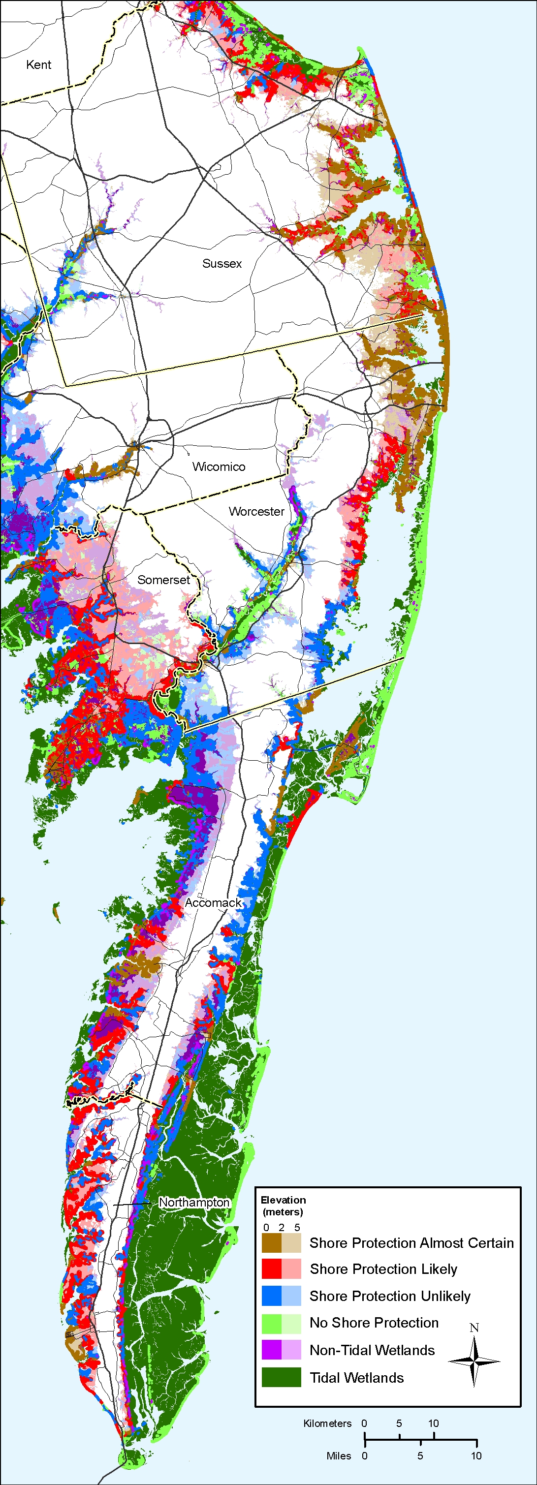
With development accounting for only 15-20% of the land area in this region, the natural shoreline processes are very likely to dominate along 80-85% of the ocean shores (Table E.2). Coastal officials generally expect all of the developed ocean shores in this region to be protected for the foreseeable future, with the possible exception of NASA's Wallops Island (which, like other federal secured installations, was outside the scope of the EPA shore protection studies). Counteracting shoreline erosion in developed areas with beach nourishment is very likely to continue as the primary activity in the near term, but preventing the inundation of low-lying lands will eventually be necessary as well. Elevating these low areas appears to be more practical than erecting a dike around a narrow barrier island.
Figure E.3 depicts the likelihood of shore protection for t he Atlantic Coast of the DelMarVa. Tables E.2 and E.3 quantify the shoreline lengths and area of low land from our study by county and likelihood of shore protection. As shown, planners anticipate that much of the shores within Delaware and the northern portion of Worcester County, Maryland (i.e., in and around Ocean City) are likely or very likely to be protected, while the southern portion of Worcester County and most of Virginia are unlikely or very unlikely to be developed and protected. Since that study was undertaken, the Corps of Engineers has begun to actively plan for beach nourishment of the northern part of Assateague Island, to prevent the increased risks of flooding to nearby developed areas that might otherwise accompany a disintegration of this barrier island.
Most land surfaces on the bayside of Ocean City were elevated during the initial construction of residences. In an appendix for EPA's 1989 Report to Congress, Leatherman concluded that the only portion of Fenwick Island where bayside property would have to be elevated with a 50 cm rise in sea level would be the portion in Delaware (i.e., outside of Ocean City). He also concluded that Wallops Island, South Bethany, Bethany, and Rehoboth Beach are high enough to avoid tidal inundation for the first 50-100 cm of sea level rise.
Along the coastal bays, market forces lead planners to expect relatively little development or shore protection on the mainland of Virginia, and relatively little open space or natural shores along the mainland of Delaware. Worcester County, Maryland, reflects a balance between development and environmental protection resulting from both a recognition of existing market forces and a conscious decision to preserve Chincoteague Bay. Shore protection is very likely along most shores opposite Ocean City. Development is expected - and hence shore protection is likely - along most shores near Ocean City inlet. In the southern portion of the county, conservation easements or the Critical Areas Act will preclude development along most of the shore. Although the Critical Areas Act encourages shore protection, and conservation easements in Maryland preserve the right to armor the shore, planners view shore protection as unlikely in these areas. Near the Virginia border, federal conservation lands make shore protection very unlikely.
Governments Plan for Development of Most Land Vulnerable to Rising Sea (PDF, 7 pp., 1.3 MB, was originally published in Environmental Research Letters , Issue 3, Volume 4 (2009).